Let’s design some stuff

with No Comments

Tara and I designed and prototyped a couple of bench and field devices recently. We have a first pass at a Falcon tube turner, a soil microbe quantifier and a soil temperature and humidity probe.

The Falcon tube turner is designed to be used on a bench to mix soil samples as part of the pH, etc. protocols. Currently it’s based on Lego components, if that basic design works we can easily fabricate a couple robust enough for our needs.

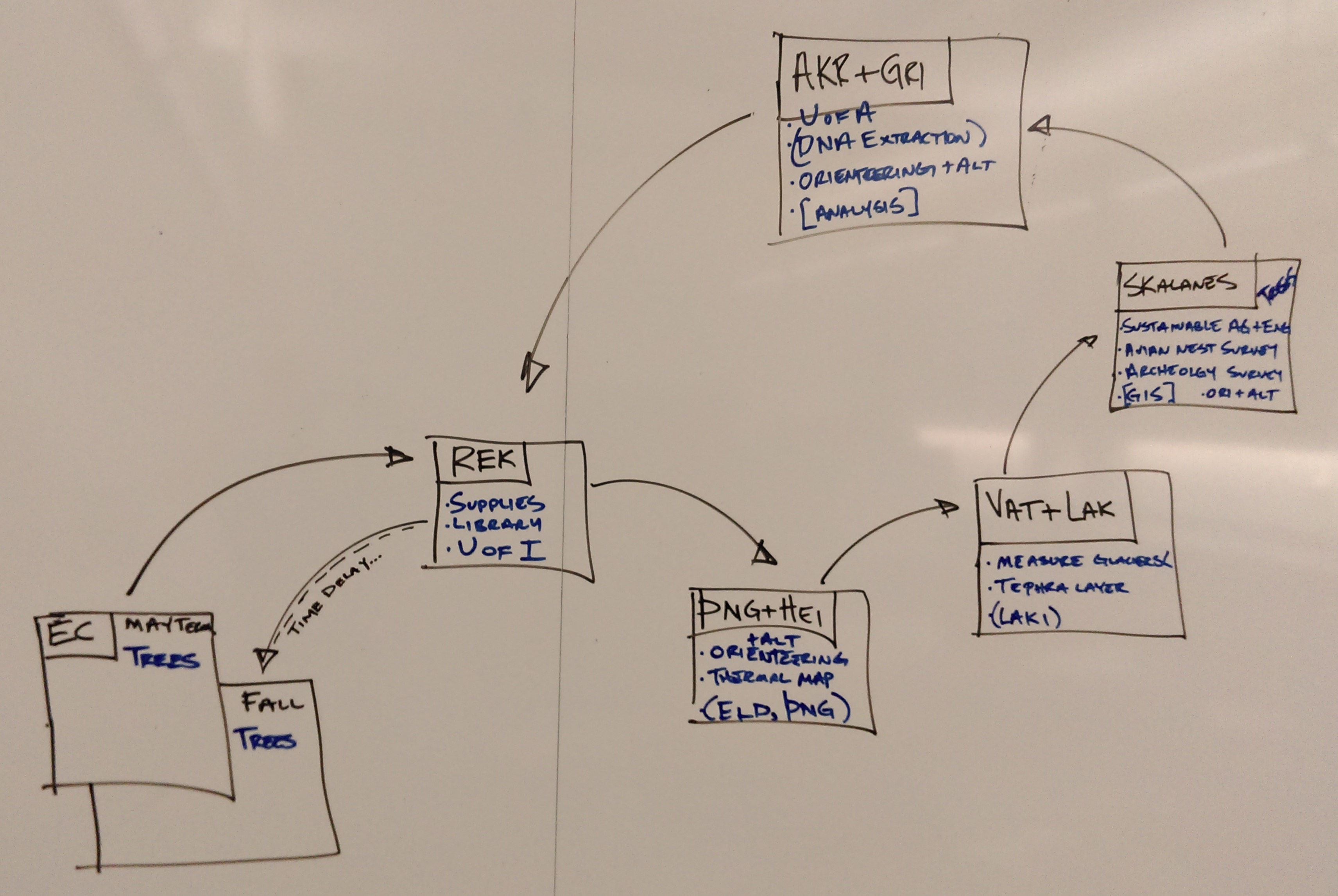
Tara has an idea to quantify the amount of soil microbes by measuring their CO2 respiration. We have data for this from 16S extractions done at one of archeology sites at Skalanes, we can re-sample there and compare the two methods. Pictured below is our first pass at a device for doing this.

IMAG0398

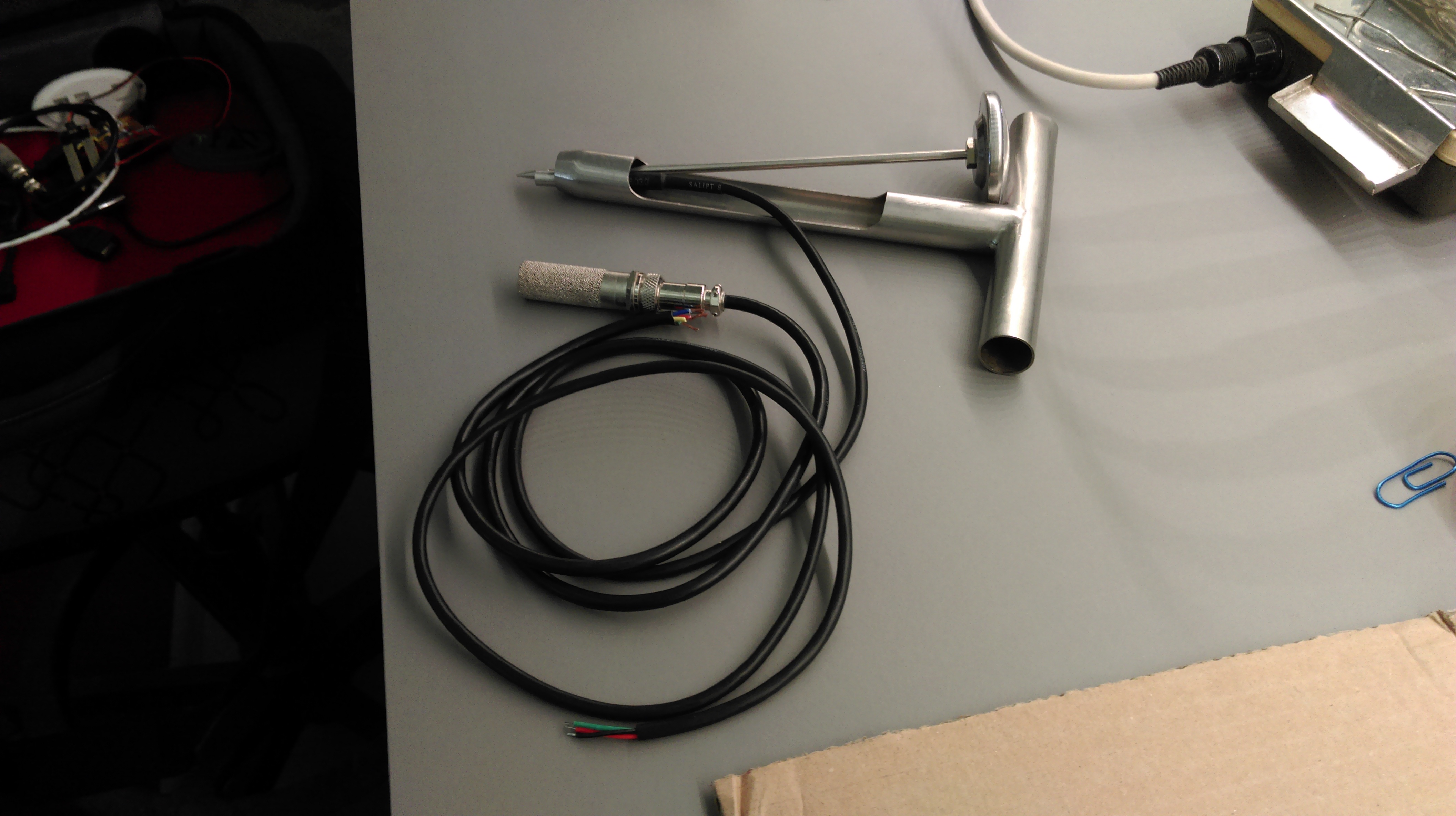
The soil temperature and humidity probe is a combination of a stainless steel soil coring tool with the two probes built-in to the end of the tube, see below (kind-of).

IMAG0399

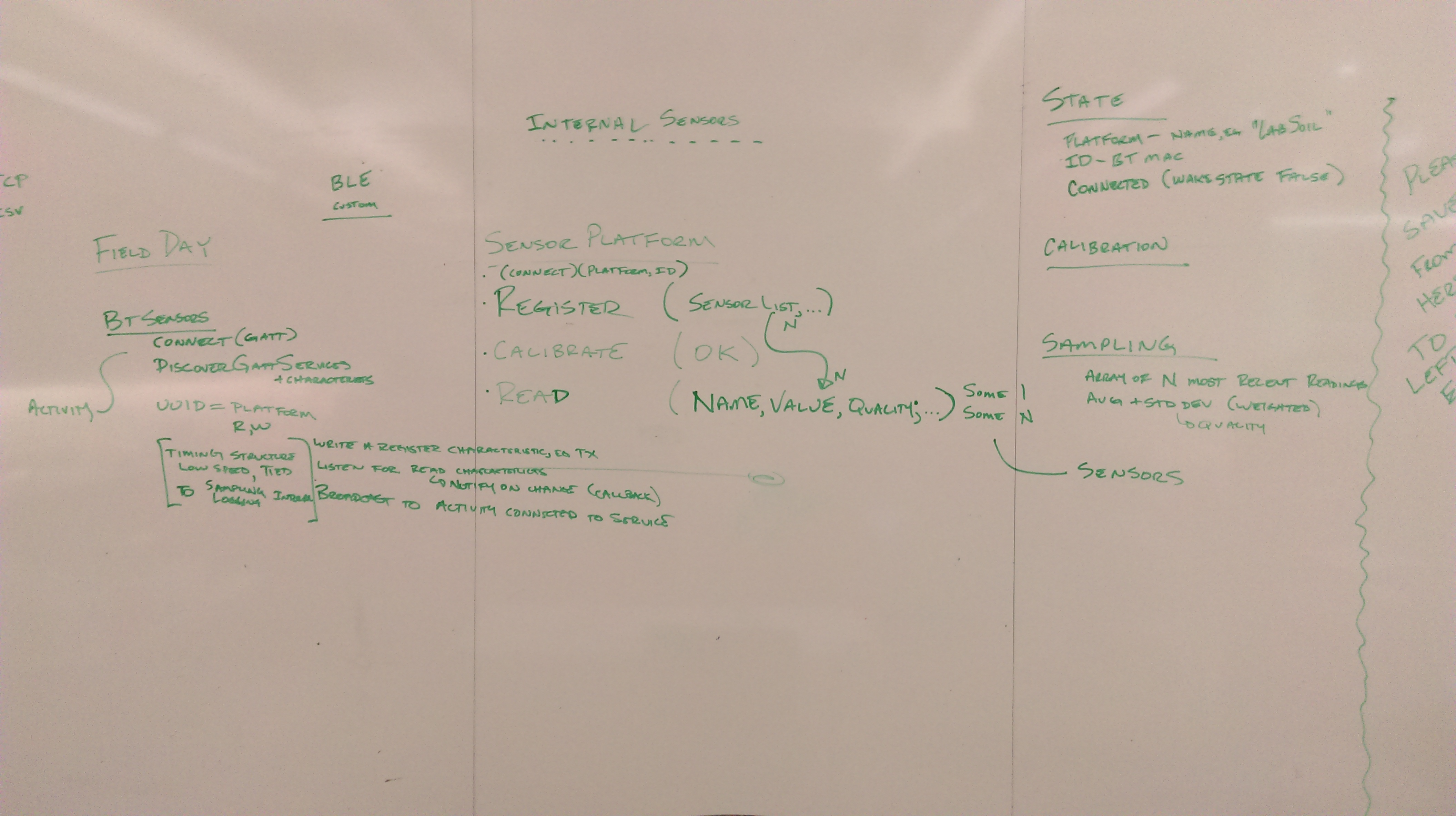
I’ve been working on reconciling the data model with the implications that Kristin brought when we worked-through the sensor <-> Arduino <-> BLE <-> Android <-> data model. Stay-tuned for the details.

This is getting really interesting

with 2 Comments

o On the archeology front, Rannveig found this article about the possibility of a new Viking site being excavated in Newfoundland. They must have stopped along the way from Scandinavia, and Skalanes seems like a nice place for that. Who knows what we’ll find.

o Nic has made some progress with LIDAR, although the gear is proving to be a bit delicate. We’ll probably order a second unit to work with. Here is an early image taken during today’s meeting. The unit is on the round table, on Nic’s screen is the developing point-cloud of the room and contents. If you look very closely you can see people on couches (/very/ closely…)

IMAG0390

o We need to sort a magnetometer before long, hopefully Patrick can loan us one.

o On the logistics front we need to make plane reservations fairly soon. All the lodging and transportation is sorted modulo the ferry to Grimsey, we’ll just wing that early in the morning of the day we travel.

o I started working with our Yocto altimeter recently, we’ll use this as part of the kit that provides more accurate x, y, and z geo-coordinates than consumer grade GPS chipsets alone do.

o Kristin and I worked through most of the details of the interface between FieldDay and the Arduino based sensor platforms. Here is a schematic of it, off to the left is the Postgres database where FieldDay pushes readings in CSV form.

IMAG0389

o I think it’s time we started the Iceland16 playlist, it looks like Spotify is currently the most popular platform for doing so.


There’s only 28 thousand days…

with No Comments

Actually it’s only about 80 days until we leave but Alicia Keys’ song is stuck in my head after hearing it this morning when we were working in the lab. I do know the answer to her second question, Iceland.

Eamon and Deeksha are making progress on the data, data model, and viz tool. We are going to create a function that measures the distance between two lat,lon pairs to make annotating the site information easier and to provide a hook for the bounding-box interface.  We wire-framed the viz tool UI, Eamon is going to construct a message to Patrick about open map tiles that we can cache on our devices.

Erin is chugging along with QGIS, we owe Patrick an adult beverage for suggesting that we use it. Nic recently discovered that there is a plug-in for it that supports LIDAR generated point-clouds in a layer (as a layer?).

I ran into Kelly Gaither (chair of XSEDE16) at IU on Friday, she strongly encouraged us to produce a poster for XSEDE16 on the UAS + LIDAR + machine learning package. She thinks it’s quite unique. Unfortunately she did remember me from the conference last summer when I hid under the table during the awards ceremony.

Next up for me is working on the high resolution Z platform and the soil temperature platform. I would like to work on Field Day too.

I love the details…

with 1 Comment

The past week has been .23 zillion small things. A few travel related, a few data, and a lot of sensor platforms. The UAS and LIDAR gear is in-house, so far Nic has made the LIDAR spin (he said it was “working”…) and the UAS has charged batteries. I’ve been meeting with Anna and Katie looking at measuring the voltage potential generated by the pH testers. Anna and I worked-through the software architecture for connecting Arduino-based sensors to FieldDay via BlueTooth. There is some data aggregation to be done on the Arduino, and we should probably look at George’s libraries.

Tara and I built a rig out of Lego for spinning 50ML Falcon tubes, if the basic principle works we can fab it out of “real” materials. That was so much easier than the last thing she asked me for, a suction filtration device on the Sunday after Christmas in Leon, Nicaragua.

I worked with Deeksha and Eamon on the data organization, cleanup, visualization, etc. It’s moving along albeit a tad slowly.

The Lilly map sale is today, I’m going to see what I can find for topos of the Wayne county area that we can use for testing the orienteering gear. Kristin and I were interviewed by Mark Brim about how we collaborate, that was fun.

Mid-February through Mid-March, 2016

with No Comments

I really have to do this more regularly. Over the past month we have:

o Worked with Nic and others to figure-out that we will start with the DJI Phantom 3 Advanced as our UAS platform, and the RPLIDAR unit as a likely candidate for the LIDAR component. Both of these are in-house as of yesterday.

o Sorted funding for this year’s trip. Since we will be doing a combination of science and developing the field studies program we are drawing from a variety of funding sources. Stay tuned for our bake sale announcements 😉

o Developed the in-country calendar, started on the pre-trip calendar.

o Sorted all the in-country travel and lodging. This was no small feat, Kristin spent about 2 weeks working on all the details including determining the cargo volume and payload for an appropriate vehicle.

o Worked with Deeksha and Eamon on organizing, labeling, and curating our field data sets from Iceland2013, Iceland2014 and Nicaragua2014.

I am hoping to wade into Arduino <-> BLE <-> Android next, and then work with Nic on the UAS/LIDAR rig. The temperature probe, ambiance with altitude, and visualization interface should follow soon after.

Mid-January to mid-February, 2016

with No Comments

After being distracted during the break by a downstream software project (Mothur, 16S analysis tool) I have spent most of my time organizing the pieces, making lists, thinking about the Icelandic Field Studies program, and looking for money. We have sent proposals to the Natural Science Summer Research fund, the Dean, and the office of sponsored research (Institutional Advancement). Our “Sanity Check” email will be sent soon. I setup Anna and Katie with the tools and materials to work on the soil pH sensor platform.

We’re in irregular contact with Oli, hopefully some of the loose ends associated with our work at Skalanes will be addressed. The biggest question is which projects will we pursue there.

Next is developing the pre-departure calendar with Kristin, working on list management (Kanbanchi), and ultimately getting back to the BLE Android interface.

Late December, 2015 and January, 2016

with No Comments

Worked with K, E, G, N, and D to develop an Icelandic Field Studies Wilderness Program proposal. The GLI has given it a light blessing, currently the Dean is considering our funding request (~$28K plus a course release in the fall) for this summer’s development costs.

Worked with Tara on pH sensors and NIR devices. After purchasing a SCiO device we will probably return it (no way to read the raw spectrum data) and we are now looking at the TellSpec unit.

Next up is putting together a sample budget for IFS and sending that for review (the “sanity check”) and working on the Android<->BLE<->Arduino. I also want to learn Kanbanchi well enough to sketch-out the IFS program with it (May, travel, Fall).

Weeks of 29 November and 6 December

with No Comments

Weeks of 29 November and 6 December:

Lots of FISC meetings and grading, this week promises to be similar. Working with K and T on list management with Kanbanchi was the only directly useful thing I did this week. Replying to Oli and GPS setup are the things I’d most like to work on this week. GLI appears to be ready to support our proposal for Field Science as Wilderness so we can begin to plan that in more detail.

Why fixed wing is better for mapping than rotary wing

with 3 Comments

Until the last few weeks, I had been assuming that we would be looking at using a quadrocopter for this research. I knew this was going to involve a lot more engineering than a balloon or kite, but until looking into it a few weeks ago, I didn’t know how much more.

Essentially, all the parts must be extremely well balanced, and thus tolerances for various parts are very, very low. This drives up manufacturing costs and makes fabricating our own parts with a 3d printer/whatever extremely time consuming and in the end, not really viable. This is compounded by increased software complexity, which I know we are all OK with conceptually, but in practice is not realistic or sustainable. Once we are in Iceland, we don’t want to need to minimize maintenance and not have the most fragile setup possible.

The only benefit of a rotary wing UAV is the ability to generate lift without horizontal thrust, which is not what we require. We are doing one long continuous flight, criss-crossing a terrain. This problem is best suited to fixed-wing UAVs, which are simpler to maintain and fly, can carry greater payloads and are not as sensitive, are much, much more efficient at generating lift, and if we run out of batteries, can glide down to earth. The biggest downside to fixed wing designs is the need for horizontal thrust to generate significant lift, making horizontal takeoff/landing necessary. This is not a problem in Iceland, where we have plenty of space. This is all leading to the final point, which is that this limited lift which can be generated by a rotary wing UAV means a payload would keep our flight times below 20 minutes, making mapping outside of a small radius around us difficult. I think we could easily get up to an hour or more on a fixed wing design with a payload with the same (if not smaller) budget.

So, in summary, even though it’s way less sexy, the fixed wing aircraft is our only real option. My next course of action is contacting old friends who are either hobbyist UAV flyers or in aerospace.

1 2 3 4 5 6 7