Hey, DNA!

with 1 Comment

Our biology and soil team has begun a practice run of the sampling, DNA extraction, and MinION sequencing protocols so that we are prepared and familiar with the process before we get to Iceland. We started by collecting soil samples from various places around Earlham campus: The Heart, the Japanese garden by Stout, the horse barn, the rain garden by the Wellness Center, and a popular social gathering place back campus. We used Maria, one of our elevation platforms, to record the coordinates of each sample site, and as a placeholder for the soil temperature readings we will take in Iceland. We put the samples on ice to preserve the living organisms within, since we are trying to identify what kind of biotic activity takes place and varies at each site, both here at Earlham and eventually in Iceland on Sólheimajökull. Back at the lab, we extracted the DNA.

Much pipette fun was had by all!

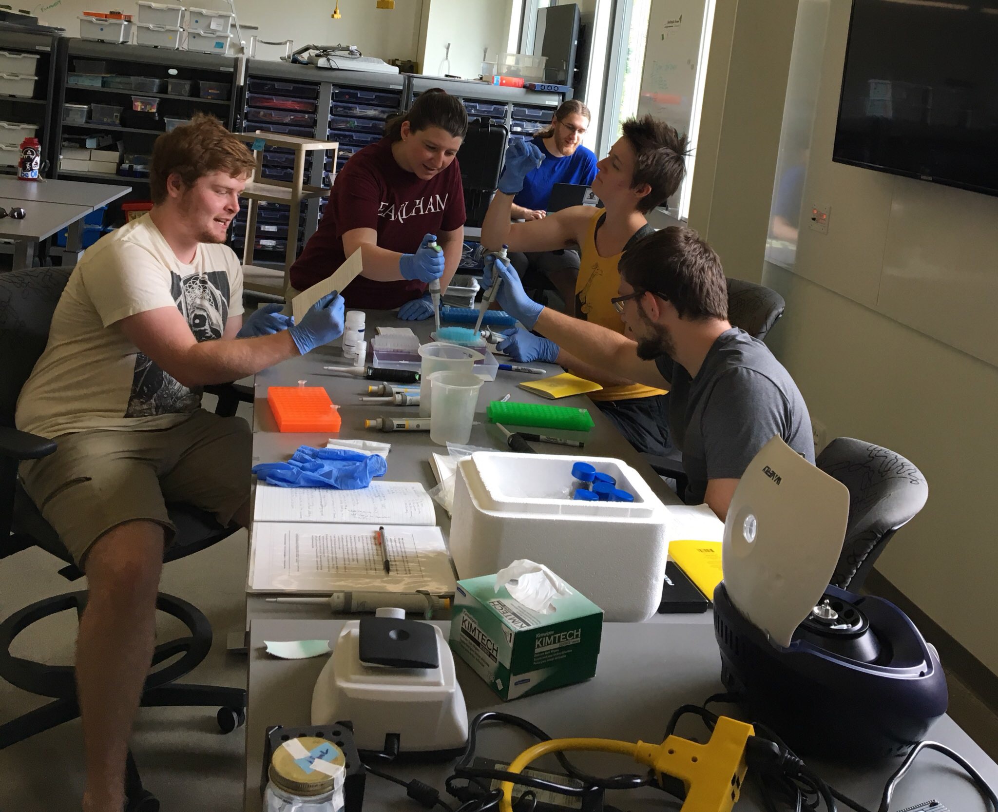
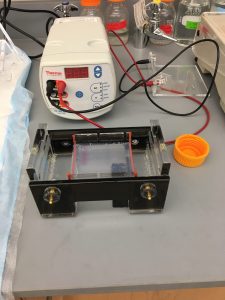
We also ran a gel electrophoresis and a Nano Drop to test the quality of the DNA. The former told us how long the strands were, and the latter told us how many nanograms per microliter of DNA we had in our samples. Both yielded positive results, meaning we have a good quality and quantity of DNA to put through the MinION.

DNA on the gel tray

We had some technical difficulties at first with this new tech, but we made it work eventually and are now working on setting up the nanopore. We are almost ready to sequence the DNA and find out what microorganisms are living all around us! We had a great win the other day with QGIS. Though we had a rocky start, we were finally able to georeference our first map! Enthusiastic cheers echoed through the Turing room, and we all celebrated with a trip to Dairy Queen.

Biology and Pockets

with No Comments

Lately we’ve been trying to figure out how to track the movement of the Sólheimajökull glacier to determine where to take samples of the soil, which we are then going to extract microbe DNA and thenot sequence that DNA with the MinION  (as seen previously in the blog post wherein Emi was being very excited about her new gadget.) Moving away from the maps, we’ve passed the location torch to Dan and Ai Lena and georeferencing software, QGIS, as I found through several hours of soul crushingly fruitless work to get our three maps to the same scale that the analog method was not the best route. However with that issue off my plate, I am freed to work on honing my soil sampling, protocol following, and biology learning skills. So yesterday, for example, Dan, Cait, and I worked on practicing our pipetting so today we can gather soils from around campus to do a practice run of our DNA extraction kit and presumably the sequencing kit as well. I also learned that bacteria and archaea are different, also that I have a pocket that combines three pockets in one.

Driving, of a sort

with No Comments

This is the first of a couple of short clips from the GoPro dashboard cam that we used in 2016 (we plan to again this year). The wheat-to-chaff ratio is pretty low, but the kernels you do find tend to be gems. In this clip we are driving down to the red sand beach on the West coast of Iceland. It’s near the end of a long day of driving from Akureyri, Nic is at the wheel with “support” from Erin, Deeksha, and the Talking Heads.

Catching-up

with No Comments

In some sense the amount of activity going on is inversely proportional to the posts we’re making here to document it… Here’s a quick summary of what we’ve been working on since my last post:

o LiDAR – We have new unit which is much more capable. We built a test-rig in Hopper to simulate having it on Kia, we’re just starting to collect data. Nic and Kellan are working on the algorithms/workflow to analyze it. Charlie is working on mounting it on Kia.
o Image processing – Kellan and Nic are working on a workflow for extracting features from the images. Charlie built a map (headed to QGIS) with marked known POIs on the Skalanes peninsula to use as part of the training data.
o Glacier forefield sampling – Tara and Charlie are developing a sampling plan and 16S RRNA workflow for processing the soil samples.
o Benchmarks for registering multi-modal data collected by sensors on the RPA.
o Discovered Siggi’s yoghurt.
o Kristin and Charlie are working on Field Day, mostly on the BLE plumbing.
o Checklist App – More news to follow.
o Gail and Charlie have done lots of logistics and planning.
o Emi is working on the avian surveys and the MinION workflow for processing glacier forefield soil samples
o New ambiance platform (single chip) is designed, construction to follow.

More regular updates to follow, we’re all psyched.

Where are we?

with No Comments

I learned this week the breadth of coordinate systems that are used to geolocate a “point” on the surface of the earth. A very nice archeological survey was done of the Skalanes peninsula about 10 years ago (as near as I can tell, it is in Icelandic). The locations of the features they catalog are given in eastings and northings from a point that I have not found documented yet. It appears to be UTM but when you use 28 W, the UTM grid zone for eastern Iceland you get kind-of-sort-of close, say within a couple of Km, but nowhere no exact. The survey team used a differential GPS, if we can obtain a copy of their database we should be able to figure-out how to convert from their coordinate system.

In other news Gail and I have finished making the hostel, ferry, and car reservations. Next up is exploring bulk airfare.

We’re back…

with No Comments

After a bit of a break from blogging we’re back. Nic and I have been puddling along with image analysis, LiDAR and the ambiance platform over the past couple of months. Recently Kellan joined us working on machine learning/feature extraction (she is also a part of the group that will be traveling to Iceland with us). Gail and I have been busy on the logistics side, we have van & car reservations, ferry tickets to Heimaey, and a few of our hostel reservations done. We have also been working with Oli on the details related to Skalanes and Gummi (Colder Climates) about the glacier work and a hike to the Laki craters.

Script for batch conversion and algorithms to find rectilinear shapes

with No Comments

This week, I and Vitalii started off by writing a bash script that takes a set of images from a directory, converts them (one at a time) and saves the converted images in a sub-directory or any other directory. The converted files are saved as TIFF and will have the same file name as the original. Because a single image takes more than 3 minutes to convert using ImageMagick, a batch of image could take quite a while. So, for now we will be using the nohup command to run the conversion in background but will work on parallelizing the conversion which should not be difficult considering that it is embarrassingly parallel.

For the rest of the week, we looked at algorithms which could be useful to detect rectilinear shapes from aerial images. We found that most of the algorithm, for accuracy, take multiple aerial images of the same region, often shot from different angles, to determine any man-made objects on the ground. However, we also found a convincing research article which uses Boldt Algorithm to find rectilinear shapes in aerial imagery.

Up next, analyzing aerial images from Skalanes

with No Comments

Vitalii, Niraj and I talked about how to proceed with the aerial images from Skalanes. For now we are going to focus on two aspects, identifying possibly anthropomorphic surface features and measuring the extent of the lupine. There are a couple of algorithms that look promising for feature ID but they require stereo images. We will look into doing that next year. There is also at least one approach that uses mono images that they will start with. The automated image conversion scripts they wrote will be used to tune the input characteristics of the images for the algorithm(s). We haven’t decided on an approach yet for the lupine but I did have an idea for doing it based on a color map seeded with human input. It’s on the back of an envelope in the Hopper lab…

The Icelandic Field Studies May Term looks good, so far…

with No Comments

Over the past couple of weeks Gail and I have spent almost all of our time working on materials describing the (almost) inaugural Icelandic Field Studies May Term, submitting them to the various campus entities, advertising it, and holding information sessions. As of tonight we have 16 applications for 14 spots, that’s much better than we hoped for given the late start. We’ll see how things go from here. Gummi, Oli and Rannveig, we’re on our way! We are especially excited that a few faculty have shown interest in participating with an eye towards leading the program themselves at some point in the future.

Next up is working with Nic, Niraj, and Vitalii on the image processing, Erin on the GIS layers for Skalanes overall (using Nic’s composite image) and the gardens, and Andy Clifford to learn about measuring glaciers.

May Term, LiDAR

with No Comments

Most of my time of late has been spent working on the Icelandic Field Studies May Term proposal. It’s overdue. Nic and I have been talking about LiDAR, we continue to think this is a promising technique to use at Skalanes.

1 2 3 4 5 7