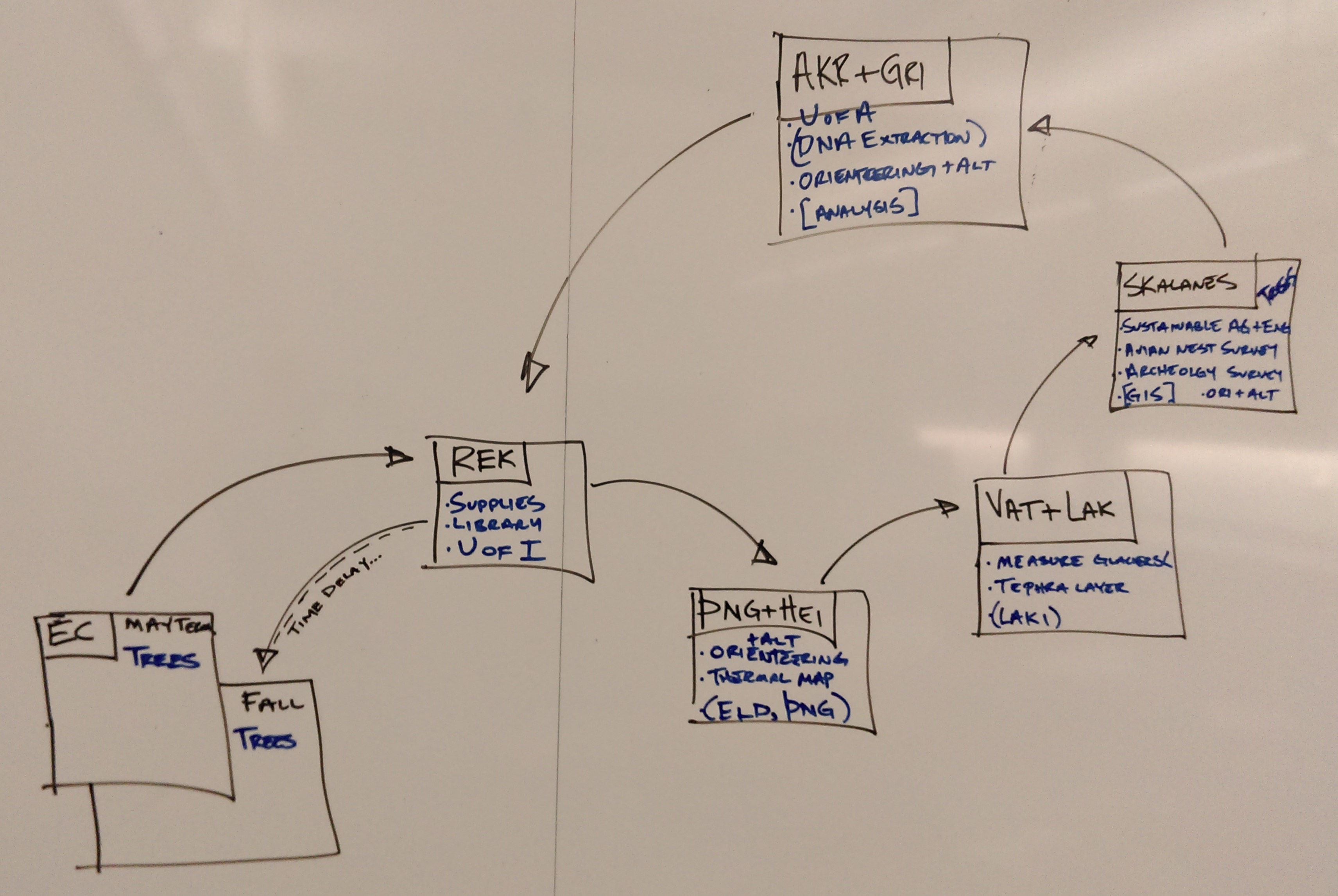
Icelandic Field Studies (IFS) is a multidisciplinary science based on-campus and off-campus program designed to immerse you in a multifaceted exploration of one of the most unique places on our planet. This program is part of the Earlham College EPIC Advantage initiative.

Fall 2023 Info Sessions
Thursday October 19   |   12 pm   |   CST103   |   Pizza Provided
Monday October 23   |   2-5 pm   |   CST227   |   Drop-in Q+A Session


Program Information

As an IFS participant, you will:

  • Study a combination of archaeology, geology, biology, environmental sustainability, computer science, history and culture of Iceland
  • Participate in data collection and contribute to long-term field studies (see below)
  • Explore the natural wonders of Iceland, tour geothermal and hydro power plants, hike on a glacier and volcano and soak in geothermal baths
  • Develop cultural competence through international travel
  • Reflect and grow through outdoor education principles and work together in a collaborative team

What are the program requirements?

  • Interest in the work we do – any student with any background is welcome!
  • A spirit of adventure and positive can-do energy
  • A 0-1 credit Spring 2024 prep class
  • 1-2 credits of Spring 2024 research
  • Present your findings at the Fall 2024 Epic Expo as a poster or oral talk
  • A valid passport (and visa if necessary – Earlham will help if you don’t have one)

How long and where will we be in Iceland?

  • 3 to 3.5 weeks, during July 2024 (exact dates TBD)
  • Reykjavík, the capitol city – we explore its downtown, the National Museum and their fabulous swimming pools.
  • Skálanes, a nature reserve on the east coast outside of Seyðisfjörður where we spend about a week collecting samples and images, doing analysis, and enjoying the birds, sea mammals, and views of the mountains and fjord.
  • Vestmannæyjar Islands, particularly Heimaey – we visit the Eldheimar museum and hike their two volcanoes, Eldfell and Helgafell. We spot puffins and other sea birds.
  • Sólheimajökull glacier, where we take soil samples and hike the nose of the glacier to measure its volume loss each year
  • Vík, our layover as we work at the glacier, with incredible black sand beaches and columnar basalt structures.

How will we live and work in Iceland?

  • We stay in hostels, with 2-4 single beds per room 
  • We cook most meals for ourselves, sharing the duties of food prep and clean up
  • We travel in large vans and airplanes to our destinations
  • We enjoy each other’s company, create shared playlists for long drives, play games together, and check in daily with the group.

Our Current Projects

Environmental DNA

Environmental DNA, or eDNA, is an emerging field in environmental sciences. It is being used to monitor species presence/absence, species abundance, and species changes by collecting samples of soil, water, and even air. Multiple samples must be collected in a sterile manner. The DNA is then extracted from the samples and sequenced. Most studies look at a particular genetic region of the ribosomal RNA, the 16S for microbes or the 18S for eukaryotes. Then, bioinformatic analysis helps determine which species are present in the sample. 

eDNA analysis can tell us a lot about how the microbes and plants in Iceland are responding to climate change. It can also tell us how creatures that live in the fjord are responding to anthropomorphic use (a massive fishing fleet, increase in cruise ship traffic, possible salmon fish farm). 

Our ongoing eDNA projects in Iceland include:

  • soils taken in a chronosequence at the forefield of the Sólheimajökull glacier
  • soils taken from a variety of microclimates and microhabitats at Skálanes (in collaboration with colleagues from John Moores University in Liverpool and Dr. Óli Pétursson of Skálanes)
  • Water samples from the Seyðisfjörðiur fjord (in collaboration with Dr. Emma Cross at Southern Connecticut State University and Dr. Óli Pétursson of Skálanes)

Quadcopter Surveying

Quadcopter surveying is a technique that allows us to measure a number of slow and rapid changes to the Icelandic landscape. We fly a grid-like pattern over an area, collecting images at a constant elevation. Software is then used to merge all the images together into a large composite image, and to create a 3d model of the area from the terrain details present in the images. We also collect high-accuracy GPS points, called GCPs (Ground Control Points), which the software can use to create very accurate representations of a large physical area. By flying the same surveys each year, we can measure the differences in such an area as it changes over time.

Some of the ways we use this technology:

  • Measure volume loss of the Sólheimajökull glacier
  • Monitor Arctic Lupine (an invasive species) spread (in collaboration with Dr. Óli Pétursson of Skálanes)
  • Identify and monitor bird nesting habitats in collaboration with Dr. Óli Pétursson of Skálanes)
  • Make coastal erosion measurements (in collaboration with Dr. Óli Pétursson of Skálanes)
  • Locate archaeological sites (in collaboration with archaeologist Rannveig Þorhallsðöttir)

Ancient DNA and Archaeology

Ancient DNA (aDNA) is a new technology that is being applied to many types of archaeology sites. In Iceland, we work in collaboration with local archaeologist Rannveig Þorhallsðöttir to  analyze aDNA from soil samples collected in various archaeological sites in East Iceland. Soil samples are transported to Earlham and aDNA is extracted in an extremely sterile environment inside the Ancient DNA Lab on campus. aDNA is sent for sequencing and analyzed with bioinformatic software suites to determine what DNA fragments are present in the samples. 

Our current aDNA projects include: 

  • Ancient DNA analysis from soils extracted at known archaeological sites at Skálanes and in the town of Seyðisfjörður (Article)