Super large backlog update

with No Comments

Okay, so a lot has happened over the last month!

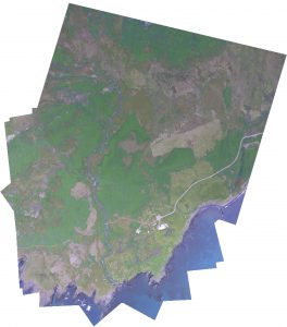
Early this month I started to dive a bit into how we are going to stitch our images together. I approached this through OpenCV so that I have access to python libraries like numpy. At its core this is taking a directory of images as an input, detecting key points, matching descriptors and features as a vector, before processing them through homography and warping the images to fit. The results are PRETTY good right now, but could be better. Ive since spent quite a bit of time working with the code getting it to accept more images on the first run. skalanes_stitch_1-copy
The Earlham College poster fair was also earlier this month and I wrote up and designed the poster detailing some highlights in our research, a pdf of the poster can be found here –> uas-poster-2016.

I suggested that Vitali and Niraj use OpenCV for object detection of archaeological sites. Ive also started to look into the different ways in which things like animal activity and vegetation health might be done through computer vision as well. Interestingly enough, vegetation is not only easy for computer vision to find but to also get rough calculations of how nitrogen heavy the plants are.

Ive continued to work with UGCS’s open software packages. I recently got integration of custom map layers (i.e., GIS) to appear in the flight program. As the majority of the sdk comes undocumented it feels a lot like reverse engineering and takes more time than I would like.

This weekend I had the intentions to fly a programmed flight over our campus to make a high resolution map that Charlie had asked me to do. I’ve since run into networking problems though and cannot proceed further until I get them figured out. I cannot get an uplink to the UAV but can receive download and telemetry data. This is mostly a networking error I suspect but one thats continuing to confuse me.

Moving forward: First off my plan is to get the ground station working correctly again and this is my highest priority. Second off, while Niraj and Vitali handle the computer vision software I will start familiarising myself a bit more with QGIS.

Script for batch conversion and algorithms to find rectilinear shapes

with No Comments

This week, I and Vitalii started off by writing a bash script that takes a set of images from a directory, converts them (one at a time) and saves the converted images in a sub-directory or any other directory. The converted files are saved as TIFF and will have the same file name as the original. Because a single image takes more than 3 minutes to convert using ImageMagick, a batch of image could take quite a while. So, for now we will be using the nohup command to run the conversion in background but will work on parallelizing the conversion which should not be difficult considering that it is embarrassingly parallel.

For the rest of the week, we looked at algorithms which could be useful to detect rectilinear shapes from aerial images. We found that most of the algorithm, for accuracy, take multiple aerial images of the same region, often shot from different angles, to determine any man-made objects on the ground. However, we also found a convincing research article which uses Boldt Algorithm to find rectilinear shapes in aerial imagery.

Up next, analyzing aerial images from Skalanes

with No Comments

Vitalii, Niraj and I talked about how to proceed with the aerial images from Skalanes. For now we are going to focus on two aspects, identifying possibly anthropomorphic surface features and measuring the extent of the lupine. There are a couple of algorithms that look promising for feature ID but they require stereo images. We will look into doing that next year. There is also at least one approach that uses mono images that they will start with. The automated image conversion scripts they wrote will be used to tune the input characteristics of the images for the algorithm(s). We haven’t decided on an approach yet for the lupine but I did have an idea for doing it based on a color map seeded with human input. It’s on the back of an envelope in the Hopper lab…

The Icelandic Field Studies May Term looks good, so far…

with No Comments

Over the past couple of weeks Gail and I have spent almost all of our time working on materials describing the (almost) inaugural Icelandic Field Studies May Term, submitting them to the various campus entities, advertising it, and holding information sessions. As of tonight we have 16 applications for 14 spots, that’s much better than we hoped for given the late start. We’ll see how things go from here. Gummi, Oli and Rannveig, we’re on our way! We are especially excited that a few faculty have shown interest in participating with an eye towards leading the program themselves at some point in the future.

Next up is working with Nic, Niraj, and Vitalii on the image processing, Erin on the GIS layers for Skalanes overall (using Nic’s composite image) and the gardens, and Andy Clifford to learn about measuring glaciers.