UAV Status and info!

with 1 Comment

We recently purchased and received the UAV drone, a Phantom 3 Advanced. In choosing the drone we looked at a variety of specifications but the important ones was price, flight time, range, camera, and hack-ablility. The P3 Advanced hit right in the sweet spot.

Its priced cheap enough to not break the bank (Charlie’s eyes nearly popped out of his head at the cost of some systems… Charlie might be the bank in this analogy) while providing adequate if not superb performance in other areas. Its got a flight time of ~23 minutes and capable of speeds of roughly 16m/s (35mph) and ascent/descent speeds of 5m/s and 3m/s respectively. When hovering it has a vertical accuracy of +/- 0.1m and horizontal accuracy of +/- 1.5m (more on this with LIDAR onboard). Though no built in wind resistance (fancy speak for the ability to rapidly increasing speed to offset sudden gusts of wind) a pilot monitoring the system will be able to adapt for such things. According to data we have from the Icelandic met office, though windy they have rarely been stronger than 9m/s during the months we will be there.

In terms of range the advanced has one of the best combo systems. On board its got both GPS and GLONAS(read: Russian GPS) capabilities and under perfect conditions will be able to travel up to 5000meters (yeah, thats not an extra 0) away from the ground station. Its ceiling is set at 120m from ground station but capable of working anywhere to 6000meters above sea level. This means that we will be able to set up virtually any flight path for the drone to take within our 23 minute flight before a battery switch is needed. Side note/idea: This will probably be shot down but, because of our need for solar panels with the energy survey if the panels work well we might be able to have a remote charging station for discharged batteries.

The biggest obstacle weather/flight wise will be working rain. I am looking into possible “water resistance” techniques for the drone that are similar to what videographers have done when filming around waterfalls and during mist or light rains. The most common is coating the electronics in some sort of $ever_dry_product, but before we go spraying our drone with strange substances Id like to be absolutely sure of its success. (Big note that this is only a weather resistance in the same way that if you go swimming in a rain coat you will still get wet)

The Advanced’s camera is also a pretty neat piece of technology. First off, its TINY and lightweight but capably of 2.7K(30fps) resolution video and 12MP stills (translates to roughly 4000 x 3000p). The Advanced has the capability to store the stills as DNG RAW format so they retain as much digital info as possible which we can then harvest IR and other spectrums from in post processing. With images and video this high of quality we will be able to apply photogrammetry to measure distances between objects for mapping purposes natively. With a LIDAR sensor added in we should be able to apply these two together and through machine learning get something incredibly comprehensive.

Hack-ability is pretty important for our needs, given that we as a group could probably be called a group of science hackers. There are two flavours of this hack-ableness for the drone; software and hardware. Software is pretty straight forward – DJI is kind enough to provide a developers SDK that gives us the ability to customise and use the drones capabilities. Whats going to be important is finding how we can get this information into the FieldDay app and how thats going to look. Hardware is another thing entirely though. The Phantom series is slightly like Apple in that its a beautifully designed chassis thats not really meant to be played around with (in fact, google only returns hardware changes that deal with aesthetics). So, of course our plan is to stick a modular LIDAR system on the back of it which may require quite a few body modifications!

Looking forward I’ll be planning out how our ground station will work with the drone. This is most likely going to mean a laptop computer + tablet + controller + batteries in the field (My laptop is a 13″ macbook pro with 16GB RAM and a 256GB SSD). The waypoint guide system or “drone” part of the UAV will probably be easiest to do with a laptop and we can get some fancy features from having an actual computer near at hand. The controller itself will be near by for manual piloting, this uses a tablet as view finder/some controls. At highest quality video (2.7K resolution, 30fps) the advanced will record about 3GB per 10 minutes. Given the flight time will be ~23 minutes it’s probably going to be ~8 to 10GB per flight captured with video + lidar. Luckily on board the Advanced can hold a 64GB extreme speed SD Card to help with storage. The flight data will most likely be stored on laptop in the field and then transferred to backups once at basecamp. As part of the ground station the laptop is probably going to be running some form of mapping program for real time mappings (this will be looked at further down the road).

Lastly and most important: The drone needs a name. I’ll be taking suggestions. (Kristin says Bob is not an option fyi)

I’ve mentioned a LIDAR system several times, so please look at this post for further reading!


GIS, GIS, GIS

with No Comments

After working on maps and looking into GIS options I finally began working with Iceland and Skalanes data shape files in GIS. Through consultation with colleagues we were able to figure out that for now our best option for using GIS software is to use QGIS which is free and open source. Charlie helped bring all of the GIS files from Oli onto our computer and I was able to take the shape files and open them in QGIS after installing QGIS. Looking through all these files is kind of a complicated process because there are lots of them. There is also lots of different data that has been collected on different things. There are basic shape files of Iceland which are useful, but so far I have not found a vector file of Skalanes specifically. Right now I am just wading through the files, visualizing them and looking at their attribute tables. One issue I have run into is translation in several of the attribute tables. Google translate has not been very helpful or reliable in translating some words so I have tried several other sites but several words are still not recognized. The next step is really to just inventory and ask Oli where we should go with these.

Much of my time has also been spent focusing on Field Studies things such as reading Island on Fire and brainstorming. In the past months we have created calendars of what needs to be done and where while we are in country. I have brainstormed lots of curriculum related things for this program, but we will go more in depth into this in May and while on course. I am excited about all this though! GIS has been really fun and I am very excited about this new program. Island on Fire is a great base point for lots of cultural and natural history related lessons and activities.

I love the details…

with 1 Comment

The past week has been .23 zillion small things. A few travel related, a few data, and a lot of sensor platforms. The UAS and LIDAR gear is in-house, so far Nic has made the LIDAR spin (he said it was “working”…) and the UAS has charged batteries. I’ve been meeting with Anna and Katie looking at measuring the voltage potential generated by the pH testers. Anna and I worked-through the software architecture for connecting Arduino-based sensors to FieldDay via BlueTooth. There is some data aggregation to be done on the Arduino, and we should probably look at George’s libraries.

Tara and I built a rig out of Lego for spinning 50ML Falcon tubes, if the basic principle works we can fab it out of “real” materials. That was so much easier than the last thing she asked me for, a suction filtration device on the Sunday after Christmas in Leon, Nicaragua.

I worked with Deeksha and Eamon on the data organization, cleanup, visualization, etc. It’s moving along albeit a tad slowly.

The Lilly map sale is today, I’m going to see what I can find for topos of the Wayne county area that we can use for testing the orienteering gear. Kristin and I were interviewed by Mark Brim about how we collaborate, that was fun.

Android for dayz

with No Comments

After having all of the logistics completed, I was able to get back to Android development. I am still working on the sqlite database implementation in Field Day. After some research, I determined that the best method for implementing a thread is by the use of Handler and Runnable objects. Before implementing this method, the Field Day was writing to the sqlite database too often causing the primary keys I’ve chosen to fail. I implemented the UI option from Seshat of selecting how often the sensor values are logged. The Handler object basically just has the runnable ‘run’ every number of seconds that is chosen by the user. Inside the runnable function, the SensorSampleActivity goes to the interface for communication between the sensor Fragment and Activity to grab the list of sensors and adds appropriate metadata (geocode, accuracy, satellites, etc). and writes it to the database. I think it is working, but I still need to do some more testing. I have to get the database off the Nexus (not particularly easy) and examine the contents.

Car, accommodations booked

with No Comments

It’s been two weeks since my last post but you can probably figure that out by looking at the dates. Last week was Spring break so I didn’t do anything (except sleep a lot). The week before however, I did quite a bit. I finished booking the accommodations for the nights we are in the west fjords. I’m so glad that is over and done with. I was able to find two Airbnb’s for a reasonable price in the west. They are roughly in two of the areas where we are probably going to be spending a decent amount of time. All of our accommodations are through Airbnb, turns out. I’ve never used Airbnb before but it seems to be pretty straight forward.

After many painful hours of Google (I probably went through at least 7 pages of ‘Iceland car rental’ multiple times), I figured out the best option for our transportation. My first thought was to get a 7-seater SUV because we don’t have as much luggage and some of the options are cheaper than getting a 9-seater vehicle. After calculating our payload, roughly 1500 pounds, and looking at the specs of some of the SUVs we were considering, Charlie and I determined that none of the SUVs would be able to hold all of that weight. I was in correspondence with some of the car companies to figure out year of the vehicles to get exact payload and still none of them would work. I ended up going with the cheapest 9-seater I could find — a 2014 Renault Trafic Mini-bus from goiceland.com.

Now all we need to do is book our flights. I’ve done a little research in that area too and we really need to book soon. The flights are just getting more expensive as the days pass.

Our best option is this:

  1. one-way flight to a large airport (JFK or YYZ (Toronto))
  2. round-trip flight from large airport to KEF
  3. one-way flight back to airport near Richmond (DAY, CVG, IND) or MIA for those of us going to XSEDE

So far, I believe the cheapest option is Toronto.

Mid-February through Mid-March, 2016

with No Comments

I really have to do this more regularly. Over the past month we have:

o Worked with Nic and others to figure-out that we will start with the DJI Phantom 3 Advanced as our UAS platform, and the RPLIDAR unit as a likely candidate for the LIDAR component. Both of these are in-house as of yesterday.

o Sorted funding for this year’s trip. Since we will be doing a combination of science and developing the field studies program we are drawing from a variety of funding sources. Stay tuned for our bake sale announcements 😉

o Developed the in-country calendar, started on the pre-trip calendar.

o Sorted all the in-country travel and lodging. This was no small feat, Kristin spent about 2 weeks working on all the details including determining the cargo volume and payload for an appropriate vehicle.

o Worked with Deeksha and Eamon on organizing, labeling, and curating our field data sets from Iceland2013, Iceland2014 and Nicaragua2014.

I am hoping to wade into Arduino <-> BLE <-> Android next, and then work with Nic on the UAS/LIDAR rig. The temperature probe, ambiance with altitude, and visualization interface should follow soon after.

Databases, Threads, and aesthetics!

with No Comments

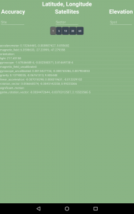
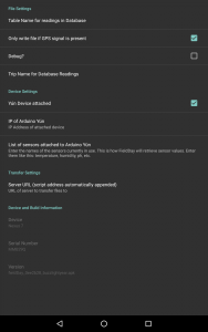
After getting most of the logistics sorted out, I’ve finally been able to get back to working on Field Day. Not a whole lot has been done because I spent most of my time working on logistics but I was able to get a few things done or started. The first thing I did was get rid of the black background for the Sensor Sample activity. We don’t have to keep it this color I was just tired of the black. I made it green because it reminded me of grass and being in the field. The next thing I added was EditTexts for Site, Sector, and Spot like Seshat had. In the data model, we also added a ‘Trip’ column but I didn’t think that there needed to be an option for that on the main screen. I put in option in the Settings page since it’s going to be constant throughout the entire trip. In Seshat, we had an option to select how often the stream to the database. I added that in Field Day as a Radio Group with customized buttons from 1 – 60 seconds. I haven’t done anything with those values yet but the visual and backbone is in place. (You can see these edits in the two pictures below — Sensor Sample on the left and Settings on the right). Ignore the ‘Table name for readings database’ on the Settings page for the time being because I have figured that out yet.

fielddaysettings

More logistics

with 1 Comment

Since my last post, I have successfully booked all of our accommodations up to Akureyri. In the South, there was one Airbnb that was directly in the middle of the two large places we want to go (Laki and Solheimjokull) and is also in the town Kirkjubaejarklaustur (a.k.a Klaustur) that is in the Island on Fire book and talks about the Reverend Jón Steingrímsson and the sermons, later to be called ‘the Fire Sermons’ that were given when the Laki volcano erupted. So, we decided that we would book that for the three nights we are in the south and then something else for the southeast. In the southeast, I found an Airbnb that is an old farm house on the coast with an organic farm. It looks really nice and from the description it looks like we’ll get to have quite a few interactions with the host. After that we are on our way to Skalanes where we already have accommodation. Akureyri was another Airbnb for three nights. I’m still working on where we are going to stay for the two nights in the West. I’ve found some Airbnb’s, I just have to confirm those with Charlie. It’s difficult to find places close enough that we don’t feel like we’re moving constantly, but close enough to attractions in the West that we won’t have to drive that far to see. I’ll have those figured out and booked this week. So far, we’ve stay significantly under budget! We had budgeted 60 per person/per night and with 7 people and 22 nights that comes to around $9240. Without the West booked, we are at $3613. Even if we were to use the 60 per person/ per night for the two nights in the west, we’d still only come out at $4453. This does not include Skalanes. We don’t know how much that is going to cost, but Oli is really hoping we won’t have to pay anything. We haven’t had confirmation on that yet, though.

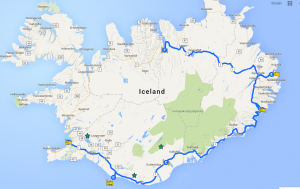
Other logistics: I also booked our ferry to and from Heimaey, and we’ve figured out our car situation. We are going to get a 7 seater SUV and bring rope to strap down our luggage on the top. It’s more practical for some of the roads we travel on. We had some trouble in the highland roads wit the 9-seater on our last trip. This SUV is a 4×4 car and is suitable for the highlands. It’s also less expensive! I also started working on a map, just placing points that are our accommodations or places we’ll stop.

Screen Shot 2016-03-07 at 8.49.48 AM