Rebuilding Kia

with No Comments

This post is meant to be a fairly general outline to repairing the gimbal on DJI P3As, containing links we used (Rei and Dan) while replacing the arm on Kia after an unfortunate encounter a very breezy day. Will also contain some notes on working on the body and replacing the landing gear.


To repair cracks in the body we used different glues based on the size of the crack. For small hairline cracks, we used Bsi super thin (blue lid). Be careful you only need a little bit and it’s easier to add more than take some off. For larger cracks, we used Bsi gap-filling medium (purple lid). When repairing the body be careful not to glue the frame together, if you don’t want to separate the top and bottom, you can slip a piece of paper in between to prevent supergluing the body together.


After futzing with the ribbon enough times we wore out the adhesive, to replace it we used auto/marine sealant.


Open the shell using a T-6, T-8, and T-9. Every screw that doesn’t connect the legs needs to come out. There are 8 locks that hold the top and bottom together, one on each of the arms, and one along each face of the body, think a compass with the ordinal as well as cardinal directions where the ordinal are the arms and the cardinal the faces on the body.

Slide a propeller in the space between the top and bottom of each arm, take care to get the propeller under the wire connecting the motor to its board. Move the propellers together, unlock each of the arms catches before starting on the body catches. Be careful with the body catches as they’re close to the delicate electronics.

https://www.youtube.com/watch?v=py2fXSvV40I   

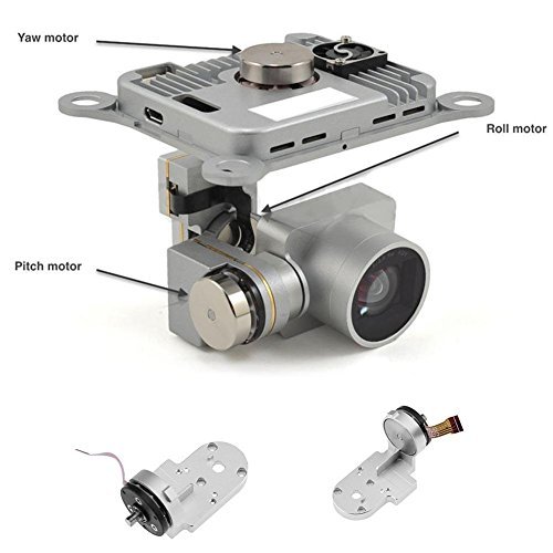
Gimbal repair(ribbon cable, arms)-Small Phillips head. Exacto knife, a small flathead, and the green squidge were all very helpful.

https://www.youtube.com/watch?v=A3vCvchnnv0

https://www.youtube.com/watch?v=gqEqu8tBg1g


To replace the ribbon start by attaching the camera connection first as it is the most difficult, and a real PIA to do when everything else is glued in place. Use exacto knives, fingernails, or small flatheads to pop the latch into and out of place, making sure that the cable is inserted all the way to the white line when installing. The cable has to be wrapped around the connection twice, which is what makes this step the most difficult. If you have to undo the connection the easiest way is to put an exacto knife between the outside of the camera case and the cable, with the blunt edge touching the wire as it enters the camera case, and twist the knife in the direction of the cable.  We found it easiest to take the cover off each tape as we did it instead of all at once.

MAKE SURE EVERYTHING IS FACING THE CORRECT DIRECTION BEFORE INSTALLING THE WIRE.


-Rei and Dan

Driving, of a sort

with No Comments

This is the first of a couple of short clips from the GoPro dashboard cam that we used in 2016 (we plan to again this year). The wheat-to-chaff ratio is pretty low, but the kernels you do find tend to be gems. In this clip we are driving down to the red sand beach on the West coast of Iceland. It’s near the end of a long day of driving from Akureyri, Nic is at the wheel with “support” from Erin, Deeksha, and the Talking Heads.

Back into the swing of things

with No Comments

Now a few weeks into the new semester its time to stop procrastinating and get back to work!

Ive started off by essentially doing what seems like mass updating of hardware, software, firmware, etc. The DJI drone system and ground control software both had to be brought up to date. Initially there were a lot of errors in getting them talking to one another again but as of Wednesday this week they are fully happy and working properly. I’ve also taken the chance to update the plug-ins and various parts of the website. Ive also made accounts on the blog for Vitalii and Niraj who will be joining us by working on some of the back end coding.

In an effort to stream line our massive photo cache I’ve copied all photos onto our media server here on campus to allow us to situate things. After talking with Charlie and Erin we have decided to sort initially by day and then by capture device. This means though that we have to map all photos to their correct day which has proved to be more difficult then I thought… If the EXIF data on the images doesn’t contain a date – the date is just set to be the most recent “creation date” which means when I copied them. Thats left me and Erin with a whole lot of images that need to be sorted and sifted by hand still. Im also still finding places where images are stored, such as the google drive, etc, and have been working on getting all of those to the server as well. Its sort of like a  big game of cat and mouse and is tedious at best.

With Niraja and Vitalii joining us I have also been doing my best in catching them up to speed on all the projects and details there in. Much of this involves working with the UAV images and how to post process them. Much of this is trying it out on proprietary software and then figuring out to best do it in large batches and with open source programs. Ive most recently been trying to figure out if its possible to get a 3D topographic image without needing to apply a LIDAR point cloud layer. While not as accurate it would certainly be quick and would be used more as an approximation.

As time becomes available, Ive also started going through all the video footage that we have saved and started to throw together a very (VERY) rough storyboard for the documentary. Im hoping to have a solid chunk of time this weekend to work on this a bit more. Really I’m just focused on getting some generic shots worked together so that we can use them as filler for voice over and context.

As things move along I’ll keep posting! Cheers!

UAV Status and info!

with 1 Comment

We recently purchased and received the UAV drone, a Phantom 3 Advanced. In choosing the drone we looked at a variety of specifications but the important ones was price, flight time, range, camera, and hack-ablility. The P3 Advanced hit right in the sweet spot.

Its priced cheap enough to not break the bank (Charlie’s eyes nearly popped out of his head at the cost of some systems… Charlie might be the bank in this analogy) while providing adequate if not superb performance in other areas. Its got a flight time of ~23 minutes and capable of speeds of roughly 16m/s (35mph) and ascent/descent speeds of 5m/s and 3m/s respectively. When hovering it has a vertical accuracy of +/- 0.1m and horizontal accuracy of +/- 1.5m (more on this with LIDAR onboard). Though no built in wind resistance (fancy speak for the ability to rapidly increasing speed to offset sudden gusts of wind) a pilot monitoring the system will be able to adapt for such things. According to data we have from the Icelandic met office, though windy they have rarely been stronger than 9m/s during the months we will be there.

In terms of range the advanced has one of the best combo systems. On board its got both GPS and GLONAS(read: Russian GPS) capabilities and under perfect conditions will be able to travel up to 5000meters (yeah, thats not an extra 0) away from the ground station. Its ceiling is set at 120m from ground station but capable of working anywhere to 6000meters above sea level. This means that we will be able to set up virtually any flight path for the drone to take within our 23 minute flight before a battery switch is needed. Side note/idea: This will probably be shot down but, because of our need for solar panels with the energy survey if the panels work well we might be able to have a remote charging station for discharged batteries.

The biggest obstacle weather/flight wise will be working rain. I am looking into possible “water resistance” techniques for the drone that are similar to what videographers have done when filming around waterfalls and during mist or light rains. The most common is coating the electronics in some sort of $ever_dry_product, but before we go spraying our drone with strange substances Id like to be absolutely sure of its success. (Big note that this is only a weather resistance in the same way that if you go swimming in a rain coat you will still get wet)

The Advanced’s camera is also a pretty neat piece of technology. First off, its TINY and lightweight but capably of 2.7K(30fps) resolution video and 12MP stills (translates to roughly 4000 x 3000p). The Advanced has the capability to store the stills as DNG RAW format so they retain as much digital info as possible which we can then harvest IR and other spectrums from in post processing. With images and video this high of quality we will be able to apply photogrammetry to measure distances between objects for mapping purposes natively. With a LIDAR sensor added in we should be able to apply these two together and through machine learning get something incredibly comprehensive.

Hack-ability is pretty important for our needs, given that we as a group could probably be called a group of science hackers. There are two flavours of this hack-ableness for the drone; software and hardware. Software is pretty straight forward – DJI is kind enough to provide a developers SDK that gives us the ability to customise and use the drones capabilities. Whats going to be important is finding how we can get this information into the FieldDay app and how thats going to look. Hardware is another thing entirely though. The Phantom series is slightly like Apple in that its a beautifully designed chassis thats not really meant to be played around with (in fact, google only returns hardware changes that deal with aesthetics). So, of course our plan is to stick a modular LIDAR system on the back of it which may require quite a few body modifications!

Looking forward I’ll be planning out how our ground station will work with the drone. This is most likely going to mean a laptop computer + tablet + controller + batteries in the field (My laptop is a 13″ macbook pro with 16GB RAM and a 256GB SSD). The waypoint guide system or “drone” part of the UAV will probably be easiest to do with a laptop and we can get some fancy features from having an actual computer near at hand. The controller itself will be near by for manual piloting, this uses a tablet as view finder/some controls. At highest quality video (2.7K resolution, 30fps) the advanced will record about 3GB per 10 minutes. Given the flight time will be ~23 minutes it’s probably going to be ~8 to 10GB per flight captured with video + lidar. Luckily on board the Advanced can hold a 64GB extreme speed SD Card to help with storage. The flight data will most likely be stored on laptop in the field and then transferred to backups once at basecamp. As part of the ground station the laptop is probably going to be running some form of mapping program for real time mappings (this will be looked at further down the road).

Lastly and most important: The drone needs a name. I’ll be taking suggestions. (Kristin says Bob is not an option fyi)

I’ve mentioned a LIDAR system several times, so please look at this post for further reading!