GIS, GIS, GIS

with No Comments

After working on maps and looking into GIS options I finally began working with Iceland and Skalanes data shape files in GIS. Through consultation with colleagues we were able to figure out that for now our best option for using GIS software is to use QGIS which is free and open source. Charlie helped bring all of the GIS files from Oli onto our computer and I was able to take the shape files and open them in QGIS after installing QGIS. Looking through all these files is kind of a complicated process because there are lots of them. There is also lots of different data that has been collected on different things. There are basic shape files of Iceland which are useful, but so far I have not found a vector file of Skalanes specifically. Right now I am just wading through the files, visualizing them and looking at their attribute tables. One issue I have run into is translation in several of the attribute tables. Google translate has not been very helpful or reliable in translating some words so I have tried several other sites but several words are still not recognized. The next step is really to just inventory and ask Oli where we should go with these.

Much of my time has also been spent focusing on Field Studies things such as reading Island on Fire and brainstorming. In the past months we have created calendars of what needs to be done and where while we are in country. I have brainstormed lots of curriculum related things for this program, but we will go more in depth into this in May and while on course. I am excited about all this though! GIS has been really fun and I am very excited about this new program. Island on Fire is a great base point for lots of cultural and natural history related lessons and activities.
I love the details…

with 1 Comment

The past week has been .23 zillion small things. A few travel related, a few data, and a lot of sensor platforms. The UAS and LIDAR gear is in-house, so far Nic has made the LIDAR spin (he said it was “working”…) and the UAS has charged batteries. I’ve been meeting with Anna and Katie looking at measuring the voltage potential generated by the pH testers. Anna and I worked-through the software architecture for connecting Arduino-based sensors to FieldDay via BlueTooth. There is some data aggregation to be done on the Arduino, and we should probably look at George’s libraries.

Tara and I built a rig out of Lego for spinning 50ML Falcon tubes, if the basic principle works we can fab it out of “real” materials. That was so much easier than the last thing she asked me for, a suction filtration device on the Sunday after Christmas in Leon, Nicaragua.

I worked with Deeksha and Eamon on the data organization, cleanup, visualization, etc. It’s moving along albeit a tad slowly.

The Lilly map sale is today, I’m going to see what I can find for topos of the Wayne county area that we can use for testing the orienteering gear. Kristin and I were interviewed by Mark Brim about how we collaborate, that was fun.

Android for dayz

with No Comments

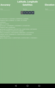
After having all of the logistics completed, I was able to get back to Android development. I am still working on the sqlite database implementation in Field Day. After some research, I determined that the best method for implementing a thread is by the use of Handler and Runnable objects. Before implementing this method, the Field Day was writing to the sqlite database too often causing the primary keys I’ve chosen to fail. I implemented the UI option from Seshat of selecting how often the sensor values are logged. The Handler object basically just has the runnable ‘run’ every number of seconds that is chosen by the user. Inside the runnable function, the SensorSampleActivity goes to the interface for communication between the sensor Fragment and Activity to grab the list of sensors and adds appropriate metadata (geocode, accuracy, satellites, etc). and writes it to the database. I think it is working, but I still need to do some more testing. I have to get the database off the Nexus (not particularly easy) and examine the contents.

Car, accommodations booked

with No Comments

It’s been two weeks since my last post but you can probably figure that out by looking at the dates. Last week was Spring break so I didn’t do anything (except sleep a lot). The week before however, I did quite a bit. I finished booking the accommodations for the nights we are in the west fjords. I’m so glad that is over and done with. I was able to find two Airbnb’s for a reasonable price in the west. They are roughly in two of the areas where we are probably going to be spending a decent amount of time. All of our accommodations are through Airbnb, turns out. I’ve never used Airbnb before but it seems to be pretty straight forward.

After many painful hours of Google (I probably went through at least 7 pages of ‘Iceland car rental’ multiple times), I figured out the best option for our transportation. My first thought was to get a 7-seater SUV because we don’t have as much luggage and some of the options are cheaper than getting a 9-seater vehicle. After calculating our payload, roughly 1500 pounds, and looking at the specs of some of the SUVs we were considering, Charlie and I determined that none of the SUVs would be able to hold all of that weight. I was in correspondence with some of the car companies to figure out year of the vehicles to get exact payload and still none of them would work. I ended up going with the cheapest 9-seater I could find — a 2014 Renault Trafic Mini-bus from goiceland.com.

Now all we need to do is book our flights. I’ve done a little research in that area too and we really need to book soon. The flights are just getting more expensive as the days pass.

Our best option is this:

  1. one-way flight to a large airport (JFK or YYZ (Toronto))
  2. round-trip flight from large airport to KEF
  3. one-way flight back to airport near Richmond (DAY, CVG, IND) or MIA for those of us going to XSEDE

So far, I believe the cheapest option is Toronto.

Mid-February through Mid-March, 2016

with No Comments

I really have to do this more regularly. Over the past month we have:

o Worked with Nic and others to figure-out that we will start with the DJI Phantom 3 Advanced as our UAS platform, and the RPLIDAR unit as a likely candidate for the LIDAR component. Both of these are in-house as of yesterday.

o Sorted funding for this year’s trip. Since we will be doing a combination of science and developing the field studies program we are drawing from a variety of funding sources. Stay tuned for our bake sale announcements 😉

o Developed the in-country calendar, started on the pre-trip calendar.

o Sorted all the in-country travel and lodging. This was no small feat, Kristin spent about 2 weeks working on all the details including determining the cargo volume and payload for an appropriate vehicle.

o Worked with Deeksha and Eamon on organizing, labeling, and curating our field data sets from Iceland2013, Iceland2014 and Nicaragua2014.

I am hoping to wade into Arduino <-> BLE <-> Android next, and then work with Nic on the UAS/LIDAR rig. The temperature probe, ambiance with altitude, and visualization interface should follow soon after.

Databases, Threads, and aesthetics!

with No Comments

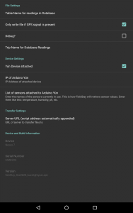
After getting most of the logistics sorted out, I’ve finally been able to get back to working on Field Day. Not a whole lot has been done because I spent most of my time working on logistics but I was able to get a few things done or started. The first thing I did was get rid of the black background for the Sensor Sample activity. We don’t have to keep it this color I was just tired of the black. I made it green because it reminded me of grass and being in the field. The next thing I added was EditTexts for Site, Sector, and Spot like Seshat had. In the data model, we also added a ‘Trip’ column but I didn’t think that there needed to be an option for that on the main screen. I put in option in the Settings page since it’s going to be constant throughout the entire trip. In Seshat, we had an option to select how often the stream to the database. I added that in Field Day as a Radio Group with customized buttons from 1 – 60 seconds. I haven’t done anything with those values yet but the visual and backbone is in place. (You can see these edits in the two pictures below — Sensor Sample on the left and Settings on the right). Ignore the ‘Table name for readings database’ on the Settings page for the time being because I have figured that out yet.

fielddaysettings

More logistics

with 1 Comment

Since my last post, I have successfully booked all of our accommodations up to Akureyri. In the South, there was one Airbnb that was directly in the middle of the two large places we want to go (Laki and Solheimjokull) and is also in the town Kirkjubaejarklaustur (a.k.a Klaustur) that is in the Island on Fire book and talks about the Reverend Jón Steingrímsson and the sermons, later to be called ‘the Fire Sermons’ that were given when the Laki volcano erupted. So, we decided that we would book that for the three nights we are in the south and then something else for the southeast. In the southeast, I found an Airbnb that is an old farm house on the coast with an organic farm. It looks really nice and from the description it looks like we’ll get to have quite a few interactions with the host. After that we are on our way to Skalanes where we already have accommodation. Akureyri was another Airbnb for three nights. I’m still working on where we are going to stay for the two nights in the West. I’ve found some Airbnb’s, I just have to confirm those with Charlie. It’s difficult to find places close enough that we don’t feel like we’re moving constantly, but close enough to attractions in the West that we won’t have to drive that far to see. I’ll have those figured out and booked this week. So far, we’ve stay significantly under budget! We had budgeted 60 per person/per night and with 7 people and 22 nights that comes to around $9240. Without the West booked, we are at $3613. Even if we were to use the 60 per person/ per night for the two nights in the west, we’d still only come out at $4453. This does not include Skalanes. We don’t know how much that is going to cost, but Oli is really hoping we won’t have to pay anything. We haven’t had confirmation on that yet, though.

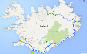
Other logistics: I also booked our ferry to and from Heimaey, and we’ve figured out our car situation. We are going to get a 7 seater SUV and bring rope to strap down our luggage on the top. It’s more practical for some of the roads we travel on. We had some trouble in the highland roads wit the 9-seater on our last trip. This SUV is a 4×4 car and is suitable for the highlands. It’s also less expensive! I also started working on a map, just placing points that are our accommodations or places we’ll stop.

Screen Shot 2016-03-07 at 8.49.48 AM

Mostly logistics this week

with No Comments

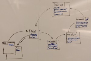
Most of the work I’ve done this week has been with the logistics aspect — calendars, flights, accommodations, etc. Charlie and I met on Monday to start working on the calendar for the months until our trip. We are trying to set dates for when we want specific projects completed — Field Day, soil sensors, flights booked. I can’t remember everything we talked about in that meeting (we wrote the calendar on the white board in hopper), but I’ll transfer that to the Drive calendars soon.

We decided that accommodations, flights and vehicles should all be done before spring break starts, but it turns out they need to be done now. I started working on booking our accommodations this week. I’ve booked the first two places and the last one. It turns out almost everywhere on the south coast is booked for the days we need, or they only have one room with one bed available. Starting for the next trips, we’ve put down that we need to book hostels as soon as we know the dates and the number of people. I’m still looking for a place on the south coast, but it’s looking like we’re going to have to stay in two different places. One place for the first two nights and another place in the southeast for the second two (most likely).

Back in the posting game!

with No Comments

Given a crazy schedule and general laziness I haven’t posted in far too long. That changes now! Over the passed few weeks I have been focusing on the energy survey, drone potential, and the android app.

I’ll start with the android app. There is now a stable naming system using the Gradle to number the APK’s accordingly. This naming scheme is probably going to changes as soon to use a tagging system as soon as Charlie, Kristin and I are able to decide on the best nomenclature. This naming system is then going to work directly with the field science blog! I have been figuring out a custom file system for wordpress that will allow us to have specific areas for upload and update that can then be automated by a script! The script is fairly straight forward and I test run has worked for uploading a test apk but I haven’t been able to configure the file system the way I would like for it to work yet. This seems like a simple but time consuming test so I hope to get to it soon.

The next thing is the drone system and potential in use. The potential is absolutely there for it and the more we look at it we realise that there is hardly any downside to one. What we have been looking at is the flight time, speed, charge, and hack-ability. How hackable the system is seems to be the deciding factor as it would allow us for the most customisation and possible use in other projects. Currently we stand deciding between the DJI phantom 3 advanced and the 3DR solo. Both entry level drone systems.


With the energy survey I will write an individual post detailing the findings and updates!

1 11 12 13 14 15 16 17 23