Balloons, hot & cold

with No Comments

This week, I spoke to a “balloonist” whose hobby of hot air ballooning will hopefully inform us more on the idea of using hot air balloons, and the kinds of things we should be thinking about. Though it’s not the same thing (he balloons at a scale of hundreds of pounds) there’s tons to learn from his informative e-mail. This advice will be critical when we consider the design of our balloon. His email is pasted below.

Hi,
There are several items to consider.  LTA/Balloons w/ABH  or hot air balloons, use a nylon rip-stop fabric that is coated (very lightly) but some are also polyester (still coated).  Rip-stop has, by name, some safety build in and the coating gives it an almost airtight quality.  One of the reasons for using these two materials is the temperature that is needed to deform.  All the hot air balloons have a small tab at the top “tell tale” or “melt link” or “Seriloc”.  These show if the temperature exceeded certain values.  Any temp over 275 def F may have done damage (allowed deformation of the nylon).  Mylar or other thin nylon material may deform at lower temperatures.  The balloons I fly use kevlar support cables that run from the bottom to the top.  They are covered to prevent UV damage.  The envelop, kinda, slides up and down on the support cables.  There are some balloons that use steel cables.
Hot Air Balloon burners are a well engineered device.  The liquid propane comes up to the burner.  The blast value allows the liquid to go into the upper coils.  These coils are in the flame path.  This superheats the propane.  The other end of the coil is in the lower part of the burner and pointed upward to the pilot lights.  Once the propane is superheated and released into the pilot lights – it will explode.  This gives the hot air balloon a very large (8ft long and 8 inch diameter) light blue flame.  This is important as it is not just something burning naturally but boosted to release up to 19 million btu’s.  This energy release can raise the temperature of 7,000 lbs (mass) of air up 100 deg F in just a few minutes.  I worked out all the math & physic’s that a hot air balloon uses to increase the energy and lower the air mass in the envelop to get to a buoyant situation.
I do tether flights for Civil Air Patrol cadets and there are issues with any type of wind when tethering.  The wind, as low as 5 mph, will start to collapse the windward side of the envelope.  This pushes the envelope material over the burner (you see the problem there).  Once the wind gets to 10 mph the risk that the aircraft will break a tether increases.  I use the Cd (coefficient of drag) of 0.3 to 0.35 when calculating the forces when tethered.  Another issue is the wind will push the flame and blow out the pilot lights.
One of the other issues you will need to address it the rate of heat input.  On hot air balloons, the pilot judges the amount of weight, ambient temperature and amount of heat loss.  This allows the pilot to use the blast valve to add heat to maintain level flight.  I can cross a 0.5 mile farm field maintaining a 6 inch height above the soybeans by adding heat at the correct times.  Since temp, humidity, pressure, etc changes daily (hourly) you will need away to adjust the heat input to the envelop.
One of the balloons I fly has a 77,000 cubic foot envelope that supports a maximum lift of 1750 lbs.  All aircraft use  a weight and balance calculation (required by the FAA).  This balloon has a basket weight of 250 lbs and envelope of 200 lbs.  The three ten gallon talks support adding 30 gals or 120 lbs of fuel.   As the fuel burns down the amount of heat needed (lower envelope temperature) requires less fuel to be used.
One of the resources that the US provides is information about weather.  NOAA/Earth System Research Laboratory,, RUC Development Group, provides some valuable information via soundings and model analysis.  We use various model results for the our location.  They provide wind speed, wind direction, temperature, etc from the ground to 45,000 feet.  Today the wind a the ground is 246 degrees at 17kts. and increases to 21kts at 92ft, 31kts at 1407ft, 41kts at 4311ft and 60kts at 10,000ft.  You won’t tether to 10,000 feet but the speed increase from 0 to 500ft can be 10kts more then ground.  That is ok for free flight but very tough for tethered flights.  http://www-frd.fsl.noaa.gov/soundings/java/
Also, when we tether a balloon we use a three point gimbaled harness.  There is a rope from the top to bottom (every 120 degrees around the balloon) and then a second rope that slides/rides the top-bottom rope which will attach to an anchor.  This allows the balloon to remain vertical when a wind hits it.  If you just tie to the top then the bottom would get pushed out from under it and if just tie to the bottom then the top would get pushed over.
It might be better with helium or hydrogen (be careful with hydrogen as it is flammable – remember the Hindenburg Zeppelin disaster).  You might find this interesting http://www.foxcap.org/content/nearspaceballoon
If you have other questions or just want to bounce some ideas, email me.
Regards,
Mike Gallant”

What I took away from this at first: we need a rigid, lightweight structure to the balloon in order to prevent collapse in windy Iceland. We should really consider using pressurized gas burners, they make a lot of heat and we need a lot of heat. Lastly, we need some seriously heatproof materials, which are also leak-proof. I hope to identify what kinds of materials we will use this week, but it may be more prudent to figure out the design of our balloon first. The design may largely be determined by the following factors: weather (wind speeds at different altitudes, precipitation) and buoyancy needs (weight of balloon, tether, burner, camera/arduino etc).
A Search for Topographic Maps and Wilderness Meetings

with No Comments

I am currently in the process of ordering topographic maps of Iceland. Charlie helped me figure out the scale we need for the maps and now I am looking for a company that sell that scale for the places that we need. We also determined which places we need maps for, which includes Skalanes, Heimay, Grimsey and many other places. 
On Wednesday at lunch I had a meeting with previous August Wilderness instructors and Zoe Wolfe (who is in charge of outdoor education right now). They had some great insights into the difficulties of creating a success program like this that is so interdisciplinary. I also asked them for the essentials of what makes an outdoor education trip/program/class what it is (see AW Meeting minutes in the Field Science-Wilderness folder of the drive). That afternoon the Wilderness/Field Science group met again to discuss more about the program (see minutes on that meeting). Right now we are just waiting to see if we get the grant that Charlie submitted a proposal for last week. We did more brainstorming on what we should include in the program and determined that measuring a glacier every year would be a crucial part of the program. Our next meeting is the Wednesday after Thanksgiving break.

Initial Sensor Testing

with No Comments

Right now I am working on wiring up each sensor individually and testing out Arduino sketches.

I have the IR temp nearly sensor wired up, just waiting on a capacitor set Charlie ordered this week. I have found found Arduino libraries that should give me everything I need to control the sensor over a serial connection. Charlie and I decided in the HIP meeting on Wednesday that I should hold off on integrating the sensors with a BLE shield until he has BLE set up on the Android/Field Day side. In the meantime I will figure out how the Arduino should package data onboard to send to Field Day.

I have started working with the pH and conductivity probes from AtlasScientific. I’m really excited about the quality of the documentation on the website and it has been easy to move forward so far.

The next steps are wiring up the laser in the laser mount and beginning building the optical density rig with Lego. I also want to look into the cheapest way to carry out the Munsell color test. I’ve found this simple visible light spectrometer that uses an Arduino board and has pretty detailed calibration options already built into the software. I’m looking more into that along with laser wiring this week. Yay spectroscopy!

Here’s a little demo film of the spectrometer. We wouldn’t use it for substance identification like he does, but for something much simpler – color detection!

Spectrometer_demo

Lots of Android Fragments!

with No Comments

This past week I have done a lot with the Android application, Field Day. I’ve implemented the basic architecture that I think we are going to use.

It makes use of Android ‘Fragments’ class. Fragments were introduced to make it nicer when building UIs. Before Fragments (introduced in API 11), whenever a new screen on the Android device was shown, a new Activity was created. Even if only one thing on the page changed, you needed to create a new activity. That meant that there were many lifecycles that needed to be tracked and maintained. That’s drained the battery and made the code more complicated than it needed to be. The Activity lifecycle is complicated. With Fragments, you can easily swap out parts of a UI and still stay in the same lifecycle. The activity that created the fragment controls its lifecycle. There’s no extra ones that need to be maintained.

Right now, there are only about 3 activities, and 5 or 6 fragments. The main screen buttons, and when you click on ‘Take a Sample’ or ‘Lab Notebook’ are all fragments with one activity maintaining them. Once a specific sample type is clicked then the SensorSample.java activity is created. There are parts of the SensorSample activity that are going to be the same no matter what type of sample we are taking. That’s why those are also fragments. Code/UI elements that will be the same for all — Geocoordinate, for example — are on the SensorSample activity’s layout file, but there’s a FrameLayout in there that can be swapped out depending on the type of sample. It really helps with stopping the creation of repetitive code.

In the SensorSample activity, I’ve already implemented a LocationListener and Manager that will listen and update the user’s location. That will be used for the Geocoordinate. It doesn’t get written to the database yet, but I have implemented in both the code and UI so it shows up and does change. I tested it!

Progress Report 11/1-7

with No Comments

This week I stopped working on the alcohol burner (at Charlie’s insistence) and started to look for Sterno. I did not find Sterno at Marsh or Tru Value, so someone else might have to pick that up. Once we have that, I’m hoping to use a lightweight plastic or balsa for a the frame for the envelope, though it remains to be seen if either is can be light and strong enough (I’m counting on balsa) .  Meanwhile I started researching potential DIY kite designs from which we could do our thermal mapping. I like the kite idea because it can be used when the hot air balloon cannot (because it’s too windy) giving us more flexibility over when and where we do our thermal mapping. The designs I’m looking at right now are box kites, due to their relatively simple design, ease of construction, strength and stability in the air. I hope to start building a kite out of dowels and TyVek this week, and if it’s stable, I’ll scale those designs to accommodate the thermal camera.

Progress Report 10/18-24

with No Comments

During these weeks I explored the possibilities of using hot air balloons. The trick was, how do I generate enough heat to get lift the thermal camera? The answer is, a LOT. We are going to need to not only generate a lot of heat, we are going to need to have a huge envelope which holds this hot air. I’ve built a couple alcohol burners already, which worked OK. Early models exploded from vapour build-up, and later models had too little pressure to stay lit. Calibrating a burner to burn for long enough while still holding together will be quite the trick. In the mean time, I’ve been thinking: hot air balloons usually float on the calmest days. If Skalines is windy, is this the best approach?

The Arctic Fox & Other Projects

with No Comments

This week did some bits and pieces of several different things. Firstly, I wrote up a paragraph with some questions for Oli. This is mostly geared toward the eider in Skalanes, and what he would like to focus on with this species. I decided also to look further into the natural history of this birds and found that Steller’s Eider is a vagrant to Iceland that is declining at an unknown rate, however populations are decreasing and the species is listed as vulnerable on the IUCN red list.

I looked at some other species on the IUCN list, including the arctic fox, because Oli wanted us to look into home range/den surveying for them. IUCN lists them as a stable population of least concern which I find interesting. I am not quite sure how they are measuring some of these species, but I am looking into that. This does not mean that they are not an important species, worth looking at. Their habitats are limited and their diets are fairly specific which can be concerning in species decline and extinction. They live in very cold conditions in the northern steppe. With global warming they are bound to get pushed further and further north to the edges of Europe and North America. Oli mentioned surveying scat with a drone but I do not see this as a very effective solution because, first of all, detecting the scat would be extremely difficult and the wind might cause issues with a small-scale drone.

On another note, we still need to do some more brainstorming into what the most effective way to survey the birds at Skalanes will be. Thermal imagining is a great idea but it may either require the rewiring of the comera we have in order to hook it up to an arduino or we would need to look at other thermal technology, which could be expensive.

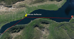
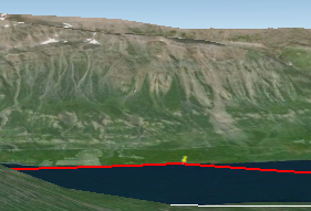
Prospect for bouncing the internet signal off of the side of the fjord looks very reasonable, we just need to ask Oli about putting up a billboard sized target on a neighbors land.Screen Shot 2015-11-09 at 3.49.47 PM    Screen Shot 2015-11-09 at 3.50.25 PM

Finally, Gail, Kristin, Charlie, Nic, Deeksha and I had a great meeting last week about the potential for a wilderness program associated with the field science work. Notes on this meeting are in the drive. Charlie submitted the grant request to the GLI committee and we are meeting again this week to further discuss the potential for this. Our next step will really be a budget and looking into what needs to happen in the next nine months, in order to plan a successful program.

Week of 8 November 2015

with No Comments

Another week, another 7 things moved 2.54cm each:

  1. Met with Gail Clark, Kristin, Erin, Nic and Deeksha to talk about if/how our field work in Iceland could be the basis for a Wilderness Program. Initially this looks good to us.
  2. Worked with G, K, E, N and D to assemble a proposal to the GLI’s development fund to cover C and G’s travel costs this coming summer. This would mean 7 of us in-country rather than 6.
  3. Ordered some bits for the soil and ambiance platforms.
  4. Worked with Tara on the science protocol design, (physical) interface design, and data protocol design for the soil platform. The data protocol design and by extension probably the other platforms too).
  5. Started to incorporate Oli’s replies and develop our next set of questions.
  6. Downloaded and installed Nic’s signed Android APK on my Nexus7! (Is this process documented? Do we have developer’s notes with the directories, release process, etc. described?)
  7. Learned how little I know about detecting Arctic fox dens.

This coming week we’ll see if roughly the same 7 things can move another inch or so:

  1. Finish next email to Oli.
  2. Work with Deeksha on data model and current data sets.
  3. Next steps for the Wilderness Program idea.
  4. Develop initial materials for Institutional Advancement to use with potential donors; meet with SallyS and AvisS.
  5. Work with Eamon on the visualization interface.
  6. Work with Erin and Eamon on the wifi link for Skalanes.
  7. Work on Field Day <-> Bluetooth <-> Platform interface.

Downloads and settings!

with No Comments

This week I worked on setting up a way to distribute the FieldDay app. The website now has a downloads page that will host our app. There will be a location for downloading the production APK which will be the compilation of Charlie, Kristin, and my code into a most recent working app. The individual coders will be able to host a most recent version of our APKs so that we can share and keep track of each others progress. During this process I coded in a way for us to upload and host nearly any file type but have restricted it back to just APK for now. Currently, all uploaded media is stored in a single directory on the server but I am trying to implement a way that we could simply scp our APK into a directory and they will be sorted into their correct location on the website. My next step is to also work on getting it so that when we distribute an APK it will be given a unique ID from our respective GIT services as another means of keeping track of everything.

On the back burner a bit, I have been working on taking the old settings page form Sheshat and implementing it into FieldDay with a few updates here and there. I will be able to spend more time on this once I get the downloads page all worked out so more updates to come!

Clean up done…now what?

with 2 Comments

I now have a master table with all our data in a consistent format,waiting to be imported into a database.
Based on Kristin’s post about,it looks like the next thing for me to start doing is learning about how to use SQLite.It will definitely be really nice to not have to deal with different versions of CSV data,and I’m excited to learn more about how to implement it.

The ability to look up later in the day records that we created earlier to associate bench values is a feature that seems particularly cool,in terms of having everything in one place at one time.


1 14 15 16 17 18 19 20 23