Basic Mapping of Iceland

with 3 Comments

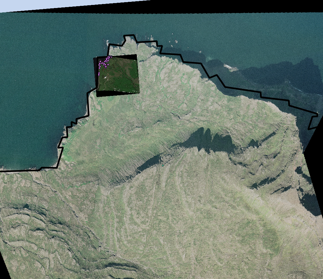
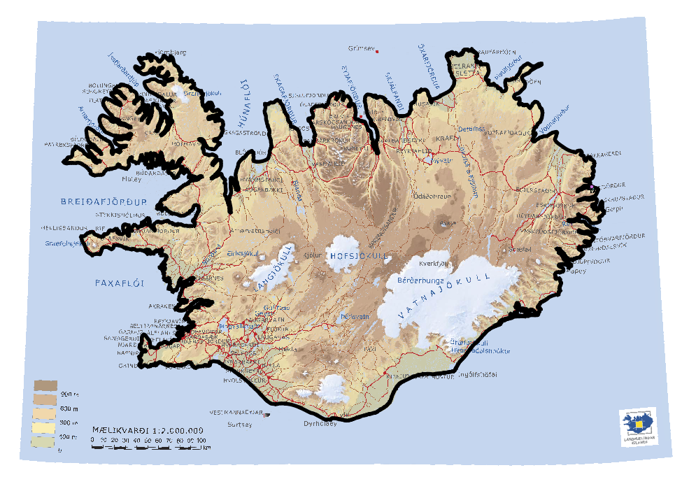
I had lots of success this week with QGIS. I met with Jose and we figured out some of the georeferencing issues in ArcGIS. From there I just had to figure out what to do in QGIS to georeference jpeg files. It took a little while due to different information from different versions but eventually I was able to use the georeferencer plugin in QGIS to match the images spatial to the rest of the layers we have right now. I also took images from google earth and brought them into QGIS the same way. Right now all of the layers are in WGS1984 because that is the projection the layers were in when we received them from Oli. However the way this projection works makes it so Iceland is very skewed. I then changed the layer projection to ISN2004/Lambert2004 (EPSG:5325). This means that the individual layers are projecting on the fly which is fine for what we are doing now however before analyzing anything I will need to individually convert the layers. I am not entirely sure how necessary this is because spatial analysis should still be accurate event if it is visually skewed (we will see). Comparison below:

WGS 84 (EPSG:4326) projection of Skalanes with a close up (higher definition) Google Earth image and some of the Eider points on top. The Skalanes government coast layer is also on top.
ISN2004/Lambert (EPSG: 5325 projection of Skalanes ('on the fly') with the Google Earth Image, Eider points and coastline.
ISN2004/Lambert (EPSG: 5325 projection of Skalanes (‘on the fly’) with the Google Earth Image, Eider points and coastline.
This is a pretty simple DEM map of Iceland from the National Land Survey of Iceland with the coastline layer (Skalanes layers are there as well however they are too small to see).


I have also added Google Earth satellite images of Heimaey. We finally received that maps of the Skalanes peninsula from Omnimaps. They will not have any of the others ready therefore I have looked into other sources and decided that we will stop at a map store in Reykjavik (Ferdakort- Map Shop) called Iðnú Bookstore. I did cut the map that we do have so we can tape the two halves of the peninsula together. I also was able to find a topo map of the Richmond area for use when testing (checked out from the library). Aside from this I have collected some books on sense of place and the value of the outdoors to make a reading collection for our trip (besides Island on Fire).

Brief Update

with No Comments

Map1EiderSo there are definitely some challenges in terms of the GIS stuff. I decided to bring all the layers into ArcGIS to see if I could do more with fixing projections in a platform I already know. It gave me the same result so then I brought a base map in which showed me that I think it is the JPEG of the Skalanes area that has the projection issues not some of the other layers (some still are nowhere). When I went to create a base map layer of that area it wasn’t really working therefore I set up a meeting with Jose and will hopefully most some more updates after that meeting.

I have also started to look at good articles regarding sense of place and other wilderness related things that would help everyone to better understand that program and in order to work things like that into this program.

Creating a Base layer and Fixing Projections

with No Comments

After consultation with professors Jose and Wendy who are teacher the GIS class, I have figured out generally what I need to do to really create a base layer. What I need to do is fix the projects for all the layers so that they are all on the same coordinate system (probably GCS World 1984). This should not be too hard, it is just taking more time since QGIS is a different platform from ArcGIS. I am also looking into the images that we have and using them as the basemap.

On another note, omni maps has still not called me back. So, we are unsure of the status of the maps we ordered several  months ago!

Solving some issues…

with No Comments
The following is from Oli’s response email:
I think the transmission might have been interrupted and there might be some files missing. 
I´d think if you could simply put up a baseline layer with a DEM from where we can possibly look at possible mini dam sites and or potential sites for wind turbines based on historical data from the weather station close by.  
The archaeology layer should have a attribute table somewhere so I we simply meet up and go through my files this summer and attach it to the site layer then I think we are pretty good.
As of for the tern site and eider nesting area it might be if interest for the IR camera work so see if it´s possible to spot recently abandoned nests since both colonies are pretty conservative in nesting site location every year.
The lupin layers are interesting too since the google earth picture of Skalanes is from last year and it could be used to compare plot sizes and preferred growth areas and then project future growth.
This was very helpful in determining a next step of creating that baseline layer of Skalanes and making sure all of the other layers are in the same coordinate system, which is what I am working on now. The other big thing I have been trying to accomplish in the past week is locating the maps that we order a while back from omnimaps (http://www.omnimap.com/cgi/graphic.pl?ice-100.jpg). I have spoken on the phone to someone several times however she has still failed to give me the information she said she would find. I just called her this morning and am now waiting for a call back because she went to check I guess.

A Continuation of GIS

with No Comments

I did some further investigation into the GIS layers that we now have. I found out some really useful information, however we need some more direction from Oli in order to be more efficient and productive in putting layers together and figuring out what is useful. I did run some conversions from vector to raster however the files were really large so I am going to try to use another tool for this conversion. Here is part of the email I sent to Oli and Rannveig:

  • There are three layer in archaeology that look similar to the map 2007 Rannveig sent. There is not any information however attached in the attribute table or just in the description.
  • Iceland layers- all pretty straightforward and informative.
  • Lupin layers
  • Eider layers
  • Terns- lots of layers with information collection of location?
There is a lot of information here but having some more direction would be helpful in putting layers together and further analyzing. Is there anything specific that you would like accomplished in considering these layers?
Once Oli responds, I will know where to go with the layers we do have. I will also be able to figure out what I will need more information on QGIS about.

GIS, GIS, GIS

with No Comments

After working on maps and looking into GIS options I finally began working with Iceland and Skalanes data shape files in GIS. Through consultation with colleagues we were able to figure out that for now our best option for using GIS software is to use QGIS which is free and open source. Charlie helped bring all of the GIS files from Oli onto our computer and I was able to take the shape files and open them in QGIS after installing QGIS. Looking through all these files is kind of a complicated process because there are lots of them. There is also lots of different data that has been collected on different things. There are basic shape files of Iceland which are useful, but so far I have not found a vector file of Skalanes specifically. Right now I am just wading through the files, visualizing them and looking at their attribute tables. One issue I have run into is translation in several of the attribute tables. Google translate has not been very helpful or reliable in translating some words so I have tried several other sites but several words are still not recognized. The next step is really to just inventory and ask Oli where we should go with these.

Much of my time has also been spent focusing on Field Studies things such as reading Island on Fire and brainstorming. In the past months we have created calendars of what needs to be done and where while we are in country. I have brainstormed lots of curriculum related things for this program, but we will go more in depth into this in May and while on course. I am excited about all this though! GIS has been really fun and I am very excited about this new program. Island on Fire is a great base point for lots of cultural and natural history related lessons and activities.

Learning Icelandic Through Mapping

with 2 Comments

Translating a website in another language is actually a very difficult task. Here are a few of the words I translated from the drop down menu for the land survey website. One I had these translated I chose staðfræðikort which translated into topography map however once here there are still a multitude of options, so I have been opening up each one to see where it is and the ones in Austerland (the Eastern Region, where Skalanes is located), are on the Lagarfljot river. I am now continuing to plow through the maps here and will switch keyword if need be.


atlaskort

aðalkort

fjllvegakort

aðalkort ferðautgafa

ferðkort

fornkort

fræðslukort

gervitunglamynd

groðurkort

grunnkort

göngukort

götukort

heildarkort

heroringjaraðskort

jarðfræðikort

jarðskjalftalkort

kort til serþarfa

loftmynd

minjakort

rettmyndakort

segulkort

serkort

sjokort

skipulagskort

staðfræðikort

sveitargelagakort

syniskort

Atlas map

primary card

mountain road map

primary card ferðautgafa

travel map

fornkort

education card

satellite image

vegetation maps

mapping

A map

street

overall map

heroringjaraðskort

geological maps

jarðskjalftalkort

card for special needs

Satelite

Historical maps

right image map

magnetic card

serko

charts

zoning map

topography maps

Country Argelaga map

son maps

Maps & Other Stuff

with 1 Comment

I have been working on finding the maps we need. I found a site, http://shopicelandic.com/collections/maps/topographic which has some maps that could be really useful for us. Charlie also found the Land Survey website, http://www.lmi.is/, which would also be great to get them from, however it is in Icelandic and needs to be translated (google only translates part of the site). I started to gather a list of longitude, latitude coordinates for the places we want to make it easier to put it into this website. The next step with this is to get a more finite list of the places we will be going.

I read an article that supports Oli’s information on arctic foxes as well. Basically, yes red foxes are pushed arctic foxes further north limiting their range and competing for resources. In the long term global warming could bring more resources, but the red fox is pushing out of its habitat because of the warming temperatures. I still do not think we can do much about tracking this for next summer, but it is good to know that populations of arctic foxes are decreases and documenting that could be important information. This article is in the google drive folder for more information.

Finally, as for the bird survey, we really just need to decide if we want to try thermal imaging using a drone/balloon. And how we would do that. If not, we need to just look into other ways of surveying, which are available.

A Search for Topographic Maps and Wilderness Meetings

with No Comments

I am currently in the process of ordering topographic maps of Iceland. Charlie helped me figure out the scale we need for the maps and now I am looking for a company that sell that scale for the places that we need. We also determined which places we need maps for, which includes Skalanes, Heimay, Grimsey and many other places. 
On Wednesday at lunch I had a meeting with previous August Wilderness instructors and Zoe Wolfe (who is in charge of outdoor education right now). They had some great insights into the difficulties of creating a success program like this that is so interdisciplinary. I also asked them for the essentials of what makes an outdoor education trip/program/class what it is (see AW Meeting minutes in the Field Science-Wilderness folder of the drive). That afternoon the Wilderness/Field Science group met again to discuss more about the program (see minutes on that meeting). Right now we are just waiting to see if we get the grant that Charlie submitted a proposal for last week. We did more brainstorming on what we should include in the program and determined that measuring a glacier every year would be a crucial part of the program. Our next meeting is the Wednesday after Thanksgiving break.

The Arctic Fox & Other Projects

with No Comments

This week did some bits and pieces of several different things. Firstly, I wrote up a paragraph with some questions for Oli. This is mostly geared toward the eider in Skalanes, and what he would like to focus on with this species. I decided also to look further into the natural history of this birds and found that Steller’s Eider is a vagrant to Iceland that is declining at an unknown rate, however populations are decreasing and the species is listed as vulnerable on the IUCN red list.

I looked at some other species on the IUCN list, including the arctic fox, because Oli wanted us to look into home range/den surveying for them. IUCN lists them as a stable population of least concern which I find interesting. I am not quite sure how they are measuring some of these species, but I am looking into that. This does not mean that they are not an important species, worth looking at. Their habitats are limited and their diets are fairly specific which can be concerning in species decline and extinction. They live in very cold conditions in the northern steppe. With global warming they are bound to get pushed further and further north to the edges of Europe and North America. Oli mentioned surveying scat with a drone but I do not see this as a very effective solution because, first of all, detecting the scat would be extremely difficult and the wind might cause issues with a small-scale drone.

On another note, we still need to do some more brainstorming into what the most effective way to survey the birds at Skalanes will be. Thermal imagining is a great idea but it may either require the rewiring of the comera we have in order to hook it up to an arduino or we would need to look at other thermal technology, which could be expensive.

Prospect for bouncing the internet signal off of the side of the fjord looks very reasonable, we just need to ask Oli about putting up a billboard sized target on a neighbors land.Screen Shot 2015-11-09 at 3.49.47 PM    Screen Shot 2015-11-09 at 3.50.25 PM

Finally, Gail, Kristin, Charlie, Nic, Deeksha and I had a great meeting last week about the potential for a wilderness program associated with the field science work. Notes on this meeting are in the drive. Charlie submitted the grant request to the GLI committee and we are meeting again this week to further discuss the potential for this. Our next step will really be a budget and looking into what needs to happen in the next nine months, in order to plan a successful program.

1 2 3